The Massacre at Pines Bridge is one of the most important Revolutionary War stories connected to northern Westchester County. Set near a critical crossing of the Croton River, the story brings together patriot fortifications, Loyalist raids, George Washington’s defensive strategy, and the dangerous no-man’s land that stretched north of New York City during the American Revolution.
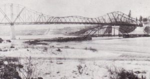
The Revolutionary War era bridge stood about 50 feet to the right in this 1905 photo. Photo: The Westchester Historical Society
About 40 miles north of the island of Manhattan, a no-man’s land witnessed many skirmishes among militia, Tories, and the British and American armies.
The Croton River and a tributary, Cross River, formed a natural boundary across almost the entire northern part of New York’s Westchester County, which is situated north of New York City. The Indians called the area Kewightequak; nine spellings and several meanings exist.
The Croton was fordable at a few points, shallow places where the flow was the widest. Crossing at these fords during the Revolutionary War exposed a raiding party for a considerable time to patriot guards.
Until the latter years of the war, the only bridge to cross the Croton was Pines Bridge. It was built by John Pyne, or Pine, who lived near the bridge. John and his brother, Peter, came from Richmond County, now Staten Island, and were local guides during the war.
Their bridge was a small wooden structure long enough to span the Croton’s bed. It was an important link of the principal north-south patriot communication line. Crossed by George Washington, the French Army, and British Major John André, who carried plans for West Point provided by Benedict Arnold as he made his way back to the British lines, it was guarded on and off by American troops.
Patriot Fortifications
After the Battle of White Plains, October 1776, Washington suspected the enemy might move on his rear as he retreated north. To secure his North Castle, presently divided into the towns of North Castle and New Castle, position, Washington ordered works erected south of Pines Bridge on the Totten Farm on Crow Hill.
During the war, patriotic Westchester inhabitants were constantly terrorized by a band of Loyalists led by Lieutenant Colonel James DeLancey. The Pines Bridge area became one of DeLancey’s strategic targets.
On December 22, 1780, Robert Benson, a member of the New York State Assembly, wrote: “I was in Westchester County last Saturday and found that there were no troops but a few Continentals at Pines Bridge, which can afford little protection, leaving the rest of the country altogether open to the ravages of DeLancey’s thieves who faithfully improved their opportunity last Monday night…”
One month earlier, Loyalist Major Mansfield Bearmore and 600 men had attempted a surprise attack in the area. Advance intelligence permitted American Lieutenant Colonel John Jameson, who had been involved in the André affair, to reinforce his post and force the Loyalists to turn away.
The patriots maintained another military post five miles north of Pines Bridge, at the present Presbyterian Church on Crompond Road in the community then called Hanover and now known as Yorktown Heights. After an attack on this position and the burning of the church, Washington opted to make Pines Bridge a more permanent post. For the command, Washington selected Lieutenant Christopher Greene, a cousin of General Nathanael Greene. The lieutenant soon would be killed along with other officers and troops during an attack by local Loyalists.
Continue To Part II
Go to Part II of Revolutionary War: Massacre at Pines Bridge.
Article updated on June 26, 2026