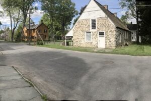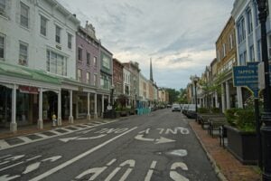
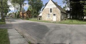
Historic Huguenot Street in New Paltz, New York, preserves stone houses associated with the town’s colonial origins. Photo: Magpieturtle, Wikimedia Commons, licensed under CC BY-SA 4.0. Cropped from the original photograph.
When the Declaration of Independence was adopted in 1776, some communities in what is now Upstate New York were already more than a century old. Albany had been a Hudson River trading center since the Dutch colonial era. Kingston had developed within the walls of a fortified settlement. Along the Mohawk, Hudson, and Wallkill rivers, other villages and farming districts had grown around trading routes, churches, mills, and colonial roads. These places were not waiting for the United States to appear on a map. They already had histories of their own.
Their beginnings were not all the same. Some received charters under the Dutch or English crown; others were defined by patents that granted enormous tracts of land, sometimes before substantial European settlement occurred. Still others were recognized as precincts or districts, which carried out local government functions before the State of New York reorganized many of them as towns in 1788. A town charter, a land patent, and the founding of a settlement are different historical events. Treating them as the same date can create a misleading picture of just how old these communities are.
Nor did the history of these places begin with the arrival of European colonists. The Hudson Valley, Mohawk Valley, and surrounding regions were the homelands of Native peoples, including Mahican, Munsee, Esopus, Mohawk, and other Haudenosaunee communities, long before New Netherland or colonial New York existed. Trade, conflict, changing land ownership, migration, and dispossession are inseparable from the histories of these early towns. Their Dutch stone houses and surviving colonial records tell only part of a much longer story.
Much of this early development followed water. The Hudson connected trading settlements with New York Harbor. The Mohawk opened a route toward the interior, and creeks running down from the Catskills powered sawmills and gristmills. German Palatine refugees established farming communities along the Schoharie and Mohawk valleys. French-speaking Huguenots founded a distinctive settlement at New Paltz. Dutch and English families established farms on both sides of the Hudson, sometimes in communities that would later become important Revolutionary War centers.
The following 25 places all have documented colonial roots before American independence. Some are cities today, others are towns, and a few began as villages whose modern boundaries were established much later. Their stories reveal a remarkable fact about New York: many communities we regard as familiar stops on modern roads were already well established when the country was born.
1. Albany
Region / County: Albany County | Capital Region
Colonial origins: Fort Orange, 1624; Beverwyck, 1652; city charter, 1686
Albany’s European colonial history begins with Fort Orange, established by the Dutch in 1624 near the upper Hudson River. The place was already an important trading region for Native communities, and the Dutch fur trade depended on their knowledge and commercial networks. In 1652, Director-General Peter Stuyvesant proclaimed the civilian settlement Beverwyck. After the English assumed control of New Netherland in 1664, Beverwyck became Albany.
Albany received the Dongan Charter on July 22, 1686, giving it a formal municipal identity nearly 90 years before the Declaration of Independence. Its surviving colonial records document merchants, households, churches, and the exercise of civic authority over generations. In 1754, delegates to the Albany Congress met here to discuss defense and relations with Native nations, while Benjamin Franklin promoted a plan for colonial union that did not take effect.
The city eventually became New York’s permanent state capital in 1797, but it was already an established port, military crossroads, and center of government before the Revolution. That depth of recorded history is why Albany belongs near the beginning of any account of Upstate New York communities older than the United States.
2. Kingston
Region / County: Ulster County | Hudson Valley
Colonial origins: Dutch settlement, 1652; Wiltwijck charter, 1661
The place now known as Kingston emerged as a Dutch farming and trading settlement in the Esopus region in the 1650s. Conflict between colonists and the Esopus people shaped its early development. Peter Stuyvesant ordered a defensive stockade built around the village, and the colonial government chartered it as Wiltwijck in 1661. The surviving street plan in the Stockade District still recalls the old fortified settlement.
English rule brought the name Kingston and a later change in political authority, but the community remained a center of agriculture, commerce, and county government. Farms in the surrounding countryside supplied food, while the nearby Hudson River provided a route toward Albany and New York City. Kingston’s early houses, churches, and civic sites provide a rare continuity between Dutch colonial life and the present city.
In 1777, Kingston served briefly as New York’s first state capital. The state’s first constitution was adopted there in April, and British forces burned much of the settlement that October. The Revolution transformed Kingston’s political importance, but its colonial origins were already more than a century old.
3. Schenectady
Region / County: Schenectady County | Mohawk Valley
Colonial origins: Dutch settlement, 1661; patent, 1684; borough, 1765
Schenectady was founded in 1661, when Arent van Curler led a Dutch colonial settlement beyond the pine plains west of Albany. Its location along the Mohawk River made it valuable to traders and farmers, but it was hardly an unoccupied frontier. Mohawk communities had long lived, traveled, and traded throughout the valley, and relations between Native nations and European colonists were central to the settlement’s survival.
A formal patent followed in 1684. The community was devastated during a French and allied Indigenous attack in February 1690, one of the best-known episodes of King William’s War in North America. Schenectady was rebuilt rather than abandoned, and its strategic position continued to attract merchants and settlers. It became an incorporated borough in 1765, still before independence, although city incorporation did not come until 1798.
Most Americans know Schenectady for General Electric or its industrial prominence in the nineteenth and twentieth centuries. But the city’s colonial history is far older, and its early development was tied to the Mohawk River trade long before factories occupied its riverbanks.
4. New Paltz
Region / County: Ulster County | Hudson Valley
Colonial origins: New Paltz Patent, 1677; settlement, 1678
New Paltz began with a group of French-speaking Huguenot refugees who secured the New Paltz Patent in 1677 after entering into a land transaction with Esopus Munsee people. The families had previously lived in and around the Hurley area after fleeing persecution in Europe. In 1678, they moved to the Wallkill River and established a small community of wooden houses, farms, and a defensive enclosure.
The settlement developed an unusual form of community government centered on the original patent holders and their descendants, sometimes known collectively as the Duzine. Over the following decades, the founding families built the stone homes that make Historic Huguenot Street one of the most evocative surviving colonial streets in the state. The houses were constructed over time; they were not all standing in the founding year.
New Paltz also has a broader history involving Dutch neighbors, Native communities, and enslaved Africans whose labor was part of the colonial economy. Its appearance today can evoke a picturesque village, but the surviving buildings preserve evidence of a complex society that had existed for nearly a century before the United States declared independence.
5. Hurley
Region / County: Ulster County | Hudson Valley
Colonial origins: Nieuw Dorp founded, 1662; renamed Hurley, 1669
Hurley began in 1662 as Nieuw Dorp, or New Village, when Dutch colonists established a farming community a few miles from Wiltwijck. The plan reflected the importance of grain production to the settlements along the Esopus Creek. The land was already part of the homeland of Esopus people, and the establishment of new colonial farms intensified disputes over territory and authority.
The village was attacked and damaged during the Esopus Wars in 1663. After English rule replaced Dutch government, settlement resumed and the community was renamed Hurley in 1669. Later patents, including grants in 1708, helped define a broader area of agricultural holdings. Its stone houses and narrow historic Main Street preserve a sense of the early Dutch and English colonial countryside.
Hurley also played a brief but meaningful role in the Revolution. After British troops burned Kingston in October 1777, New York officials sought refuge in the surrounding countryside, including Hurley. The village that had begun as a colonial farming outpost became part of the story of the new state’s survival.
6. Marbletown
Region / County: Ulster County | Hudson Valley
Colonial origins: Settlement documented by 1669; patent, June 25, 1703
Marbletown was being settled by European farmers by 1669, according to the town’s own historical account. It developed around agricultural land between the Esopus and Rondout watersheds, where small farms and mills supported nearby communities. A 1672 account describes dozens of early houses, showing that the locality was already more than a proposed grant on a colonial map.
The Marbletown Patent was issued on June 25, 1703, and trustees subsequently recorded meetings concerning land distribution and public access to roads, wood, and stone. These proceedings are a useful reminder that patents did not necessarily create a settlement from nothing. In Marbletown’s case, residents had already been living and working there for decades before the patent established clearer legal arrangements.
Stone Ridge and other hamlets in today’s town still reflect the area’s agricultural roots. During the Revolution, nearby communities became temporary meeting places as New York officials moved after the burning of Kingston. Marbletown’s colonial history is both a story of everyday farm settlement and part of the larger history of the Hudson Valley during wartime.
7. Rochester in Ulster County
Region / County: Ulster County | Catskills and Hudson Valley
Colonial origins: Colonial settlement before 1703; Rochester Patent, June 25, 1703
This is not the city of Rochester on the Genesee River. The Town of Rochester in Ulster County traces its early European settlement to the Mombaccus area, where farms and mills developed along the Rondout Creek and its tributaries. Colonial land records identify activity before the formal patent, including grants and references to milling operations during the late seventeenth century.
The Rochester Patent was granted in 1703, the same year as the neighboring Marbletown Patent. The record of trustees and land distribution reveals the practical work of organizing a dispersed rural population. Settlers needed secure access to water, timber, mill sites, and roads in a landscape still connected to Indigenous histories and older travel routes.
The modern town took its legal form under New York State in 1788, after independence. Yet the patent and the evidence of earlier settlement show why Rochester can legitimately appear in a list of places with colonial origins. Its pre-Revolutionary roots are far older than its later municipal incorporation.
8. Rhinebeck
Region / County: Dutchess County | Hudson Valley
Colonial origins: Dutch settlement around 1686; Rhinebeck Precinct, 1737
The lands of present-day Rhinebeck were home to the Sepasco people before Dutch settlers acquired tracts along the east side of the Hudson during the late seventeenth century. The town dates its early European settlement to 1686. Farms developed around the old road corridor and waterways, with later settlement also spreading toward the Hudson River landing at Rhinecliff.
German Palatine families became another important part of Rhinebeck’s colonial population in the early eighteenth century. They helped develop farming communities, churches, and mills alongside the older Dutch settlements. The Rhinebeck Precinct was established in 1737, creating a more defined unit of local administration under the colonial government. The town itself was incorporated in 1788, and the village later followed in the nineteenth century.
Rhinebeck’s history reaches beyond its present reputation for shops and restaurants. Its colonial road connections linked farms to Albany and New York City, and several surviving early buildings testify to the agricultural communities that preceded the Revolution.
9. Poughkeepsie
Region / County: Dutchess County | Hudson Valley
Colonial origins: Place name recorded in a 1683 deed; colonial precinct, 1737
Poughkeepsie’s name appears in a colonial land deed dated 1683, evidence of how early the site along the Hudson River entered European property records. The name itself preserves an older Indigenous place-name tradition. Dutch settlers established farms and mills in the area before the eighteenth century, and the river provided a vital transportation connection with larger Hudson Valley markets.
The Poughkeepsie Precinct was formed in 1737, long before the city became a modern municipality. It developed amid a changing Dutchess County landscape of farms, roads, churches, and river landings. The town received post-Revolutionary recognition in 1788; the village incorporated in 1799 and the city much later, in 1854. These distinctions matter because Poughkeepsie’s community history is substantially older than the date on its city charter.
Poughkeepsie became a key political center in the Revolutionary era and hosted New York’s convention to consider ratification of the United States Constitution in 1788. By then the town had already existed as a colonial community for generations. It is a particularly revealing example of an old settlement that later acquired new governmental importance.
10. Claverack
Region / County: Columbia County | Upper Hudson Valley
Colonial origins: Seventeenth-century Dutch landholding; Claverack District, 1772
Claverack grew out of a long history of Mahican land, Dutch agricultural settlement, and complicated colonial property claims along the eastern side of the Hudson. Lands associated with the Claverack name were contested among the Van Rensselaer interests and the family of Jan Frans Van Hoesen, who received an English patent in 1667 for part of the area. Those claims help establish the community’s roots well before independence.
The surrounding countryside developed as productive farmland and supported households, churches, roads, and small trading centers. Colonial administrators established Claverack as a district in 1772, when the area was still part of Albany County. Columbia County did not yet exist, and the modern town boundaries would be shaped by later divisions of land and government.
Claverack is easy to overlook beside nearby Hudson, but that city developed later around its waterfront. Much of the older inland agricultural history belonged to places such as Claverack. The town’s nineteenth-century identity grew from a landscape whose farms and property records reached deep into the colonial period.
11. Kinderhook
Region / County: Columbia County | Upper Hudson Valley
Colonial origins: Settlement around 1670; colonial charter/patent, 1686–1687
Kinderhook’s Dutch-derived name means ‘children’s corner,’ a reminder of the cultural influence of New Netherland along the upper Hudson. The area was home to Mahican people before European settlement, and a farming community began developing around 1670. It occupied an advantageous position among agricultural lands, waterways, and routes leading toward Albany and the Hudson River.
The broader town received a colonial charter or patent in 1686–1687, according to federal historic-preservation records, and the village was being referred to as a community by the 1690s. Road connections helped it become a crossroads for travelers moving between Albany, New York City, and New England. Inns, farms, and local institutions gave Kinderhook a distinct identity long before 1776.
Kinderhook would later become famous as the birthplace of President Martin Van Buren in 1782, but its story reaches back more than a century before his birth. The town’s early history illustrates the endurance of Dutch place names and rural traditions in a region that passed from Dutch to English and then American control.
12. Coxsackie
Region / County: Greene County | Upper Hudson Valley
Colonial origins: European settlement by 1663; colonial district, 1772
Coxsackie stands on land long associated with Mahican communities and a Native-derived place name whose exact translation remains disputed. Dutch settlement developed during the seventeenth century. Pieter Bronck built the oldest portion of the house now preserved as the Bronck Museum in 1663, giving the town a tangible surviving connection to its early colonial history.
The settlement expanded into farms and small commercial centers along the Hudson River. A district was created in 1772, and New York State formally organized the town in 1788. Its present municipal status therefore belongs to the post-Revolutionary period, even though some of its houses and its history of farming were already well established under English colonial rule.
Coxsackie’s later identity became closely tied to river trade, brickmaking, and transportation. These nineteenth-century developments are familiar in local history, but the much older Bronck house and seventeenth-century land records are what make the town especially appropriate for this list.
13. Newburgh
Region / County: Orange County | Hudson Valley
Colonial origins: Palatine settlement, 1709; Newburgh Precinct, 1763
Newburgh’s European settlement is generally traced to 1709, when German Palatine immigrants established a community along the Hudson River. Early records associated the place with Palatine Parish near Quassaick Creek. Later Scottish and English settlers joined the population, and the community developed as a river settlement with farms, roads, and religious institutions.
The area became a separate colonial precinct in 1763. This was more than a change of place name: precinct government allowed residents to manage certain local affairs under the Province of New York. Formal village incorporation did not arrive until 1800, and the city charter dates to the nineteenth century, so the colonial settlement and later city must not be given the same founding date.
Newburgh entered national history during the Revolution when George Washington used the Hasbrouck House as his headquarters in 1782–1783. The famous events at headquarters took place in an existing settlement that had already been part of the Hudson River corridor for more than 70 years.
14. New Windsor
Region / County: Orange County | Hudson Valley
Colonial origins: Highlands Precinct by early 1700s; separate precinct, 1763
New Windsor’s colonial history began in an area of Hudson River land patents, farms, and river approaches south of Newburgh. A large grant to Captain John Evans in the 1690s was later vacated, and local organization evolved under the Highlands Precinct in the early eighteenth century. The settlement grew around farms, roads, and access to the river.
The colonial government divided the Highlands Precinct into New Windsor and Newburgh in 1763. Remarkably, New Windsor’s own archived precinct minutes survive from that year and list the officials selected at its first meeting. Those records provide a more reliable foundation for the town’s age than a romantic founding legend. They show a functioning local community before American independence.
New Windsor later played an important role in Revolutionary War military logistics. Nearby New Windsor Cantonment became a major Continental Army encampment in 1782–1783, and the New Windsor area also preserves places associated with the Knox family and the supply network of the Hudson Highlands.
15. Goshen
Region / County: Orange County | Hudson Valley
Colonial origins: Wawayanda Patent, 1703; settlement documented from 1712
Goshen grew on lands included in the Wawayanda Patent of 1703, part of a broader colonial effort to divide the fertile interior of Orange County into large private holdings. The Village of Goshen’s official history identifies Christopher Denne as an early settler in 1712. Farms and roads developed around the settlement as more families moved into the region.
The community was already established before the Revolution, although its formal municipal status and village incorporation came later. Goshen’s agricultural economy drew heavily on the surrounding fertile land and on routes that connected the interior with Hudson River ports. Its early churches, county institutions, and village center developed from the needs of a growing eighteenth-century population.
Today Goshen is widely known for county government, historic streets, and the area’s horse-racing traditions. The most important detail for this article, however, is that its roots go back to the first half of the eighteenth century, not to the later formation of the modern village.
16. Schoharie
Region / County: Schoharie County | Schoharie Valley
Colonial origins: Palatine German settlements, 1712–1713
The Schoharie Valley had been traveled and inhabited by Native communities long before German Palatine families began arriving in the early eighteenth century. Refugees who had first been settled along the Hudson sought farmland farther west. In 1712 and 1713, families established several small settlements, or dorfs, along fertile land near Schoharie Creek. Their early years were marked by hunger, difficult travel, and disputes over the ownership of land.
Schoharie became known for farming and mills, and its agricultural output later made the valley important to Continental Army supply. The village’s historic Old Stone Fort began as a church built in 1772, before American independence, and was fortified during the Revolution. Its survival is a reminder that this was already a settled, organized region when the war began.
The modern town and county were organized under later governments, so neither should be assigned the arrival year of the first Palatine families as an incorporation date. But the colonial settlement is clearly documented, making Schoharie one of the best examples of an Upstate community whose local history is older than the nation.
17. Mamakating
Region / County: Sullivan County | Western Hudson Valley
Colonial origins: Mamakating Precinct established December 17, 1743
Mamakating’s history demonstrates the distinction between a colonial precinct and a modern town especially clearly. As settlement spread through the western reaches of Ulster County, the provincial government needed a way to organize residents living beyond the boundaries of older towns. On December 17, 1743, it created Mamakating Precinct, using a name already associated with the wider region.
The precinct contained a much larger territory than today’s Town of Mamakating and included lands later separated into other municipalities. Residents engaged in farming, forestry, and the work of maintaining roads and local government. Colonial records show that Mamakating had an administrative identity decades before the Revolution, but the town was formally established by New York State on March 7, 1788.
Sullivan County itself was not formed until 1809, when Mamakating became part of the new county. That sequence of changes explains why a present-day Sullivan County town can trace its institutions to colonial Ulster County. The continuity lies in the older community, not in unchanged county lines.
18. Scotia
Region / County: Schenectady County | Mohawk Valley
Colonial origins: Alexander Lindsay Glen’s settlement, about 1658; village incorporation, 1904
Scotia’s colonial beginnings are older than those of many much larger Upstate cities. Alexander Lindsay Glen, a Scottish-born settler with connections to New Netherland, established a home on the north bank of the Mohawk River around 1658. The land was part of Mohawk territory, and local histories describe a transaction involving the Mohawk people. Glen named his estate Scotia, recalling the country from which he had come.
The river crossing opposite Schenectady made this a valuable location for travelers, trade, and agriculture. Glen’s descendants continued to develop the property, and the surviving Glen-Sanders Mansion contains eighteenth-century construction associated with the family. Over time, additional houses and businesses gathered around the old riverside settlement. The early community’s existence is supported by documentary history, even though the boundaries of the modern village were not yet defined.
Scotia was incorporated as a village only in 1904, roughly two and a half centuries after Glen’s arrival. Its story is a reminder that the age of a settlement cannot be determined simply by looking at the date when it became a municipality. The place where people live today grew from a much older Mohawk Valley community.
19. Schaghticoke
Region / County: Rensselaer County | Capital Region
Colonial origins: Colonial community documented by 1675; district organized, 1772
Schaghticoke, near the meeting of the Hoosic River and Tomhannock Creek, has a history that long predates American independence. The place is closely associated with Indigenous communities, including Schaghticoke people whose settlement and political relationships were central to its seventeenth-century history. The town’s account describes a colonial ceremony in 1675 in which Governor Edmund Andros planted a symbolic ‘Tree of Welfare’ near the waterway junction.
The community’s position near waterways and frontier routes made it part of a changing network of Native, Dutch, and English interests. Land grants and the administration of the area through Albany complicated questions of ownership and authority. Schaghticoke was organized as a colonial district in 1772. It was not incorporated as a New York State town until March 7, 1788, after the Revolution.
By the nineteenth century, mills and farms transformed the area, and the modern village grew around waterpower on the Hoosic River. Yet its colonial identity had already been recorded a century earlier. Schaghticoke adds an important Capital Region example to the list and illustrates why Indigenous and colonial histories must both be considered when discussing the age of an Upstate community.
20. German Flatts
Region / County: Herkimer County | Mohawk Valley
Colonial origins: Palatine settlement, 1722; Burnetsfield Patent, 1725
German Flatts grew from the movement of Palatine German families into the upper Mohawk Valley in the 1720s. They established farms along both sides of the river in a region where the Oneida and other Haudenosaunee nations had much older political and cultural connections. By 1722 settlers were occupying land in the fertile river flats, and a major grant known as the Burnetsfield Patent followed in 1725.
The name German Flatts originally described a wider district of German-speaking settlements, not simply the boundaries of the modern town. Families cultivated land, constructed churches and mills, and traded along a frontier corridor that was exposed to military conflict during the French and Indian War and the American Revolution. Some settlements were raided or temporarily abandoned, and the experiences of residents were bound up with relations among European empires and Native nations.
The modern municipality received its legal form after independence, but the area had served as a colonial community for more than half a century by 1776. German Flatts broadens this list beyond the lower Hudson and demonstrates how older settlement spread into the Mohawk Valley.
21. Saratoga (Old Saratoga)
Region / County: Saratoga County | Upper Hudson Valley
Colonial origins: Saratoga Patent, 1684; settlement at Old Saratoga by 1688
Old Saratoga refers to the historic settlements along the upper Hudson around today’s Town of Saratoga and Schuylerville, not to the modern resort city of Saratoga Springs. The area’s waterways were central to Indigenous life and movement for generations. In 1684, a group of colonial landholders obtained the Saratoga Patent, and Bartel Vroman is recorded as a settler in 1688.
The river junctions and routes through the area made it a desirable but vulnerable military and farming frontier. Johannes Schuyler developed a farm and mills in the early eighteenth century, and the Fort Saratoga community became important during repeated periods of fighting among the British, French, and Native nations. A larger colonial district called Saraghtoga existed by 1772, although the modern town was formed in 1788.
The Battles of Saratoga in 1777 made the region famous for the American victory that helped change the course of the war. That dramatic event occurred on land whose European colonial history was already nearly a century old. It should not be confused with Schaghticoke, a different historic community.
22. Catskill
Region / County: Greene County | Northern Catskills and Hudson Valley
Colonial origins: Dutch river settlement in the seventeenth century; town organized in 1788
The mouth of Catskill Creek attracted Dutch colonial settlement during the seventeenth century because it offered shelter and access to the Hudson River. Local historical accounts place a Dutch port settlement around 1650. The community developed around creek crossings, agricultural land, mills, and the movement of goods by water, in territory with a much older Mahican history.
The future town grew as a place where goods from the Catskills interior could reach the river. When Catskill was formally organized as a town on March 7, 1788, it was still part of Albany County; Greene County would not be established until 1800. Its municipal paperwork therefore postdates independence, but the settlement clearly does not.
Nineteenth-century steamboats, tanning, ice harvesting, and mountain tourism transformed the area, giving Catskill a new commercial identity. The older creekside settlement remains the essential starting point for that story, however, and explains why this town can trace its roots well before the founding of the United States.
23. Saugerties
Region / County: Ulster County | Hudson Valley
Colonial origins: Dutch settlement before 1663; Palatine West Camp, 1710
Saugerties developed from early Dutch farming and milling settlements along Esopus Creek and the Hudson River. The local history of Barent Cornelis Volge, an early landholder whose activities predate 1663, connects the place to the earliest generations of Dutch colonial expansion north of Kingston. The site was already important as a place to reach the river and use the waterpower of nearby creeks.
A second major chapter began in 1710 when German Palatine refugee families were settled on the western side of the Hudson at a place that became known as West Camp. Their migration was connected to a British colonial program intended to produce naval supplies. The experiment had enormous human consequences, and some families subsequently moved to the Schoharie and Mohawk valleys.
The present town was organized in 1811, long after both colonial episodes. Saugerties later became well known for its mills and industrial growth, but its origins reach to the Dutch and Palatine communities that occupied this portion of the Hudson Valley before independence.
24. Halfmoon
Region / County: Saratoga County | Capital Region
Colonial origins: Half Moon colonial district, 1772; town formed in 1788
Halfmoon occupies a historically strategic part of the landscape near the Hudson and Mohawk rivers. Trade and travel had long crossed this meeting of waterways, and colonial settlement grew in a region closely tied to Albany and the routes northward toward Lake Champlain. The area’s early history predates its present-day suburban development by generations.
In 1772, the colonial government organized the Half Moon district, one of the large districts into which the territory north of the Mohawk was divided. Halfmoon became one of the original Saratoga-area towns in 1788. The Town of Halfmoon preserves a record of its first town meeting in April of that year, making the transition from colonial district to state-chartered town particularly easy to document.
The distinction makes Halfmoon a good example of a place that qualifies through its pre-independence community and governmental history, not because its town incorporation occurred under British rule. Its old district lands were gradually divided as Waterford, Clifton Park, and other municipalities developed.
25. Fishkill
Region / County: Dutchess County | Hudson Valley
Colonial origins: Rombout Patent, 1685; European village settlement, 1714
Fishkill occupies land associated with the Rombout Patent of 1685, an enormous colonial land transaction involving Wappinger territory in southern Dutchess County. Dutch settlers established a community in the area around 1714. Its name combines Dutch words for fish and creek, an appropriate description of a place where waterways, farms, and roads would become important to everyday life.
The town’s colonial history can be traced through settlement, church life, and the development of routes through the Hudson Highlands. Fishkill Precinct was formed in the eighteenth century, while the modern town was created after independence. The separate Village of Fishkill was incorporated much later, illustrating again why municipal incorporation dates cannot stand in for the age of the community itself.
During the American Revolution, Fishkill developed into a major supply center for the Continental Army. Barracks, storehouses, medical facilities, and military transportation brought activity to a place that had already served colonial farmers and travelers for decades. The surviving historical landscape makes Fishkill one of the clearest links between settlement-era New York and the founding of the United States.
What connects these communities is not a single style of government or a common founding year. It is the persistence of places through sweeping political change. Dutch and English colonial rule gave way to revolution and statehood. Counties divided, precincts became towns, and villages eventually incorporated as cities. Yet people continued to live, farm, trade, worship, and build in locations whose names were already familiar long before 1776.
For another perspective on how later transportation reshaped older communities, explore our article on 25 Erie Canal towns that helped build Upstate New York. Our discussion of where Upstate New York begins also explains why the lower Hudson Valley is sometimes classified differently from the Capital Region and Mohawk Valley.