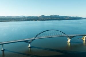

Aerial view of the Lake Champlain Bridge connecting Crown Point, New York, with Vermont across Lake Champlain. Photo: Frame Craft 8 / Shutterstock.com
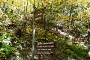
New York and Vermont share a border unlike any of New York’s other state boundaries. In the north, Lake Champlain separates much of the two states, making bridges and ferries especially important. Farther south, the border becomes an overland line through Washington and Rensselaer counties, where state highways connect the Capital Region and eastern New York with Bennington, Rutland, the Champlain Valley, and the Green Mountains.
For drivers, the basic rule is simple: the principal highway and bridge crossings between New York and Vermont are toll-free. The paid crossings are the vehicle ferries on Lake Champlain. Travelers should also watch seasonal ferry schedules, winter weather, and the differences between major highway routes and smaller rural crossings.
Travel note: Ferry schedules, fares, construction, bridge restrictions, and winter road conditions can change. Drivers should check 511NY, Vermont 511, Lake Champlain Ferries, and the appropriate transportation agency before traveling.
Are New York–Vermont Border Crossings Tolled?
The main highway and bridge crossings between New York and Vermont do not charge tolls. U.S. Routes 2 and 4, the Lake Champlain Bridge, and the major state highways along the southern portion of the border are all toll-free at the state line.
Lake Champlain ferries are different. The Grand Isle–Plattsburgh, Charlotte–Essex, and seasonal Fort Ticonderoga–Shoreham crossings charge fares based on the vehicle, passengers, and in some cases vehicle length. Lake Champlain Transportation currently operates two regular crossings: Grand Isle–Plattsburgh and Charlotte–Essex. The former Burlington–Port Kent route is not currently listed as an operating crossing.
U.S. Route 4 — Hampton to Fair Haven
U.S. Route 4 crosses from Washington County, New York, into Fair Haven, Vermont. On the New York side, the route approaches the border through the Hampton and Whitehall area. In Vermont, U.S. 4 becomes a divided limited-access highway shortly after entering the state and continues toward Castleton and Rutland.
The crossing is toll-free and serves passenger vehicles, buses, and commercial traffic. It is one of the most important highway links between eastern New York and central Vermont, particularly for travelers heading toward Rutland and the central Green Mountains.
U.S. Route 2 — Rouses Point to Alburgh
At the northern end of Lake Champlain, U.S. Route 2 crosses from Rouses Point, New York, into Alburgh, Vermont. This is the northernmost direct road crossing between the two states and provides access from Clinton County into Vermont’s Grand Isle region.
The route is toll-free and carries both passenger vehicles and commercial traffic. Once in Vermont, U.S. 2 continues through the Lake Champlain islands and provides connections toward Burlington and northwestern Vermont.
This crossing is sometimes confused with U.S. Route 11 because U.S. 2 begins in New York at U.S. 11 in Rouses Point. U.S. 11 itself continues north toward the Canadian border; it does not cross Lake Champlain into Vermont.
Lake Champlain Bridge — Crown Point to Chimney Point
The Lake Champlain Bridge connects Crown Point in Essex County, New York, with Chimney Point in Addison, Vermont. On the New York side, Route 185 connects the bridge with Routes 9N and 22; on the Vermont side, the roadway continues as Vermont Route 17.
The current bridge opened in November 2011 after the original 1929 bridge was closed in 2009 and demolished later that year because of serious structural deterioration. The replacement restored a vital road connection between the two sides of the lake.
The bridge is toll-free and carries passenger vehicles, commercial trucks, bicycles, and pedestrians. Sidewalk connections also tie the bridge to the historic areas at Crown Point and Chimney Point, making this one of the few New York–Vermont crossings that can be experienced on foot.
New York Route 7 / Vermont Route 9 — Hoosick to Bennington
New York Route 7 crosses the state line east of Hoosick in Rensselaer County and continues into Vermont as Vermont Route 9. This is the principal southern highway connection between the Capital Region and Bennington.
The crossing is toll-free and carries passenger vehicles, buses, and commercial traffic. Route 9 continues through Bennington and then east across southern Vermont, while connections in Bennington provide access to U.S. Route 7 toward Manchester and points farther north.
It is important not to confuse this crossing with Vermont Route 7. New York Route 7 does not become Vermont Route 7 at the state line; it becomes Vermont Route 9.
New York Route 22A / Vermont Route 22A — Hampton to Fair Haven
New York Route 22A begins at Route 22 in Washington County and runs north to the Vermont state line, where it continues as Vermont Route 22A. The route provides another toll-free connection into the Fair Haven area and continues north through western Vermont toward Vergennes.
This is an important regional road for passenger traffic, agriculture, and commercial vehicles traveling through the Champlain Valley. It is particularly useful for trips that do not require the faster U.S. 4 corridor.
New York Route 149 / Vermont Route 149 — Granville to Pawlet
New York Route 149 runs east from the Lake George and Queensbury area through Fort Ann and Granville before reaching the Vermont state line. Across the border, Vermont Route 149 continues a short distance through Pawlet to Vermont Route 30.
The crossing is toll-free and serves local residents, farm traffic, slate-industry traffic, and visitors moving between Washington County and southwestern Vermont. Route 149 also provides a useful connection from Interstate 87 and the Lake George area toward Vermont.
New York Route 67 / Vermont Route 67 — Eagle Bridge to North Bennington
New York Route 67 crosses the Vermont state line east of Eagle Bridge and continues as Vermont Route 67 through Shaftsbury toward North Bennington. Vermont transportation records identify Route 67 beginning at the New York state line and continuing through the North Bennington area toward Route 7A.
This toll-free crossing is used mainly for local and regional traffic rather than long-distance interstate travel. It provides a quieter alternative for travelers moving between northeastern Rensselaer County and the Bennington area.
New York Route 313 / Vermont Route 313 — Cambridge to Arlington
New York Route 313 crosses from Washington County into Vermont and continues as Vermont Route 313 toward Arlington. Much of the route follows the Batten Kill valley, making it one of the most scenic road crossings between the two states.
The crossing is toll-free and is used by local residents, anglers, cyclists, and visitors exploring the Batten Kill, Arlington, and southwestern Vermont. It is a slower rural route rather than a major freight corridor.
Rural Crossings Along the Poultney River
Several smaller roads also connect rural communities in Washington County, New York, with communities in western Vermont near the Poultney River and the southern end of Lake Champlain. These local crossings are far less heavily traveled than U.S. 4 or the major state routes.
Drivers using these roads should pay attention to posted bridge limits, seasonal conditions, and winter maintenance. A road that appears to be a convenient shortcut on a map may be narrow, lightly traveled, or unsuitable for larger vehicles.
Grand Isle–Plattsburgh Ferry
The Grand Isle–Plattsburgh ferry connects Gordon Landing in Grand Isle, Vermont, with Cumberland Head near Plattsburgh, New York. Lake Champlain Transportation identifies this as its northern crossing, operating 24 hours a day, seven days a week, year-round.
The trip is approximately two miles and normally takes about 14 minutes. As of September 2026, the standard one-way fare for a vehicle under 19 feet with its driver is $12.25, with additional charges for passengers and longer vehicles. A fuel surcharge may also apply.
The ferry carries passenger cars, commercial vehicles, motorcycles, bicycles, and walk-on passengers. No vehicle reservations are taken; vehicles are handled on a first-come, first-served basis.
Charlotte–Essex Ferry
The Charlotte–Essex ferry connects Charlotte, Vermont, with the historic village of Essex in Essex County, New York. The crossing is approximately three miles and normally takes about 25 minutes.
Lake Champlain Transportation operates this route on schedules that change by season. As of September 2026, the standard one-way fare for a vehicle under 19 feet with its driver is $12.25, with additional passenger charges and higher rates for longer vehicles. A fuel surcharge may apply.
This crossing is especially useful for travelers moving between the Adirondacks and the Burlington area without driving north to Rouses Point or south to the Lake Champlain Bridge. Like the Grand Isle route, it does not accept ordinary vehicle reservations.
What Happened to the Burlington–Port Kent Ferry?
The Burlington–Port Kent ferry was once one of the best-known Lake Champlain crossings, linking downtown Burlington with Port Kent in Essex County, New York. It has not returned to regular service, however. Lake Champlain Transportation’s current public schedule lists only two operating crossing locations: Grand Isle–Plattsburgh and Charlotte–Essex.
Travelers should therefore not plan a trip around a Burlington–Port Kent vehicle ferry. Anyone traveling between Burlington and the Adirondacks should use one of the active ferry routes or a highway crossing.
Fort Ticonderoga Ferry — Ticonderoga to Shoreham
The Fort Ticonderoga Ferry provides a seasonal vehicle crossing between Ticonderoga, New York, and Shoreham, Vermont. This small independent ferry crosses a narrow section of Lake Champlain near the historic Fort Ticonderoga area.
The ferry is operating for the 2026 season, with service scheduled from May into October. The crossing takes about 7 to 8 minutes, the ferry holds approximately 18 cars, and the operator lists a maximum gross vehicle weight of 15 tons. The ferry does not accept credit or debit cards, so travelers should be prepared to pay in cash.
Schedules can change during the season, and the ferry does not run continuously through the winter. Travelers should check the operator’s current schedule before making the drive.
New York to Vermont by Train — Ethan Allen Express
New York and Vermont are also connected by passenger rail. Amtrak’s Ethan Allen Express operates daily between New York City and Burlington, traveling north through the Hudson Valley, Albany-Rensselaer, Schenectady, Saratoga Springs, and Fort Edward before entering Vermont.
In Vermont, the train stops at Castleton, Rutland, Middlebury, Ferrisburgh-Vergennes, and Burlington. For travelers who do not want to drive, it provides a direct New York–Vermont connection through the same general corridor served by the highways of Washington County and western Vermont.
Which New York–Vermont Crossing Should You Use?
For travelers headed toward Rutland and central Vermont from the Capital Region, U.S. Route 4 is usually the most direct highway crossing. For Bennington and southern Vermont, New York Route 7 and Vermont Route 9 are the main routes. Route 313 is a scenic choice for Arlington and the Batten Kill valley, while Routes 22A, 149, and 67 serve more local and regional trips.
For northern Vermont, U.S. Route 2 at Rouses Point provides a toll-free road connection through the Lake Champlain islands. The Grand Isle–Plattsburgh ferry is especially useful for the Plattsburgh and Burlington regions and operates around the clock. Charlotte–Essex offers a shorter crossing farther south, with departure times changing by season, while the Lake Champlain Bridge provides a dependable road connection between Crown Point and Chimney Point.
For more on northern New York transportation and Lake Champlain history, read our My Experience Taking a Greyhound from NYC to Plattsburgh, History of the Battle of Plattsburgh, and MacDonough Monument, History of Plattsburgh’s Famous Monument.
Sources
New York State Department of Transportation — Official Touring Route Descriptions
Vermont Agency of Transportation — Town Highway Maps
New York State Department of Transportation — History of the Lake Champlain Bridge
Lake Champlain Transportation Company — Current Ferry Routes
Lake Champlain Ferries — Grand Isle–Plattsburgh Schedule
Lake Champlain Ferries — Grand Isle–Plattsburgh Rates and Restrictions
Lake Champlain Ferries — Charlotte–Essex Schedule
Lake Champlain Ferries — Charlotte–Essex Rates and Restrictions
Fort Ticonderoga Ferry — 2026 Service Information
Amtrak — Ethan Allen Express Timetable