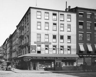
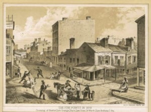
The Five Points in 1859, showing the crossing of Baxter, Park, and Worth Streets. From The New York Public Library.
The Five Points was one of the most notorious neighborhoods in 19th-century New York, but the name has almost vanished from the modern street map. The district once occupied part of Lower Manhattan where Chinatown and the Civic Center meet today, just northeast of City Hall and around the present-day junction of Worth and Baxter Streets.
The neighborhood became famous for extreme poverty, overcrowded tenements, street gangs, saloons, reform missions, and sensational newspaper accounts. But Five Points was also home to generations of working-class New Yorkers, including free Black residents and waves of Irish and other immigrants. Its streets became a place where cultures met, clashed, and influenced one another in ways that helped shape New York.
Much of the old neighborhood was eventually demolished for parks, courthouses, municipal buildings, and street changes. Yet pieces of the geography still survive. If you know where to look, you can still stand near the old Five Points intersection and trace parts of the neighborhood on today’s map.
Where Was Five Points in New York City?
Five Points was in Lower Manhattan, northeast of City Hall, in an area now divided between Chinatown and the Civic Center. The neighborhood did not have one permanently fixed official boundary, and historians and mapmakers have drawn it somewhat differently depending on the period being discussed.
The historic core centered on the intersection of three streets: Orange Street, later renamed Baxter Street; Cross Street, later known as Park Street and partially surviving today as Mosco Street; and Anthony Street, later renamed Worth Street. Those three streets created five corners, giving the neighborhood its name.
A useful modern approximation places the old district between the vicinity of Canal Street on the north, Park Row and Chatham Square toward the south, the Bowery toward the east, and Centre Street toward the west. Those should be understood as approximate historical edges rather than precise official borders.
Why Was It Called Five Points?
The name came from the unusual street geometry at the meeting of Orange, Cross, and Anthony Streets. Because the three streets crossed at different angles, they created five distinct corners rather than a conventional four-way intersection.
Orange Street became Baxter Street. Anthony Street became Worth Street. Cross Street was later renamed Park Street, and only a short fragment of that old route survives today as Mosco Street.
Paradise Square, a small public open space, stood near the center of the district and became one of the places most closely associated with Five Points in 19th-century accounts and illustrations.
Can You Stand Where Five Points Was Today?
Yes, although the original five-corner intersection no longer survives in its 19th-century form.
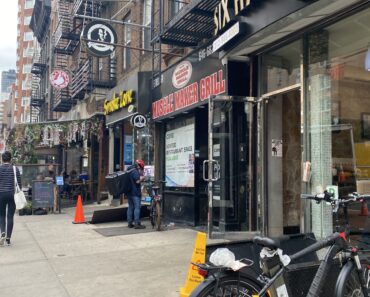
The closest modern location is around Worth Street and Baxter Street at the southwest edge of Columbus Park. Mosco Street, the surviving remnant of old Cross Street, runs nearby. Standing in this part of Chinatown places you very close to the historic heart of Five Points.
The street pattern has changed enough that there is no single painted marker showing the exact five points. The best way to understand the location is to compare modern streets with historical maps showing Worth, Baxter, and the former Cross or Park Street.
How Large Was the Five Points Neighborhood?
Five Points was larger than the single intersection that gave the district its name. The term came to describe a broader working-class neighborhood surrounding the intersection and extending through nearby streets, alleys, tenements, and courts.
Its boundaries also shifted over time. As streets were renamed, widened, closed, or absorbed into later civic construction, the exact geography changed. That is why modern descriptions of Five Points should be treated as historical approximations rather than as the equivalent of a present-day neighborhood with formally recognized borders.
What Did Collect Pond Have to Do With Five Points?
Long before Five Points existed, much of the surrounding landscape was dominated by Collect Pond, also known as Kalch-Hook. The spring-fed pond covered roughly 48 acres and was once an important source of freshwater for colonial New York.
As the city expanded during the 18th century, industries including tanneries and other workshops gathered around the pond and increasingly polluted the water. By the end of the century, Collect Pond had become badly contaminated.
City officials ultimately decided to drain and fill the pond. Canal Street took its name from the drainage canal constructed in connection with the effort to carry water away from the area.
How Did the Filling of Collect Pond Affect the Neighborhood?
Filling a former pond and wetland did not instantly create ideal building land. The filled ground remained damp and drainage problems persisted. Buildings constructed over the former pond and surrounding marshy terrain could suffer from settlement, moisture, and poor sanitary conditions.
Those environmental problems were only one part of the neighborhood’s decline. As wealthier residents and businesses moved elsewhere, older structures were subdivided into inexpensive rooms and tenements. Low rents attracted people who had few housing options elsewhere in the rapidly growing city.
Over time, the combination of overcrowding, poverty, inadequate sanitation, deteriorating housing, and limited public services helped give Five Points its notorious reputation.
Who Lived in Five Points?
Five Points became one of New York’s most diverse working-class districts during the 19th century. Free Black New Yorkers lived in and around the neighborhood, and large numbers of Irish immigrants settled there, especially during and after the Great Famine of the 1840s.
Other immigrant and working-class communities also passed through the district as New York’s population expanded. Families lived in cramped tenements, worked in nearby trades, ran small businesses, attended churches and missions, and created social networks that rarely appear in the sensational crime stories later written about Five Points.
Archaeological discoveries made beneath the former neighborhood in the 1990s later revealed thousands of ordinary household objects. Those artifacts helped historians reconstruct a much fuller picture of family life, work, consumption, and community in Five Points.
Was Five Points Really as Dangerous as Its Reputation?
Five Points unquestionably contained severe poverty, overcrowding, crime, and dangerous housing conditions. But its reputation was also enlarged by sensational journalism, reform literature, political rhetoric, and later popular culture.
Visitors and writers often presented the neighborhood as an exotic urban underworld. That language sometimes obscured the lives of ordinary residents who worked, raised families, attended religious institutions, and built communities there.
Modern historical interpretation therefore has to hold two ideas at once: the suffering and disorder were real, but some of the most lurid stories about Five Points became exaggerated as they were retold.
What Was the Old Brewery?
One of the most notorious buildings associated with Five Points was the Old Brewery, a former late-18th-century brewery near the center of the neighborhood that was later converted into crowded housing.
By the 1830s and 1840s, the structure had become synonymous with the worst conditions in Five Points. Contemporary descriptions referred to dark passageways and spaces with names such as Murderers’ Alley and Den of Thieves.
Stories later claimed that murders occurred there with extraordinary frequency, sometimes even repeating the legend of a murder every night. Those claims became part of Five Points mythology, but they should not be treated as verified crime statistics.
In 1852, Methodist missionaries acquired the Old Brewery and demolished it. The Five Points Mission was subsequently established on the site as part of a larger reform effort aimed at the neighborhood’s residents.
The Five Points Gangs and the 1857 Dead Rabbit Riot
Street gangs were a real part of the Five Points story, although their identities, alliances, and membership were often less fixed than later books and films suggest.
The Dead Rabbits became one of the names most closely associated with Five Points and Irish-American street politics. The Bowery Boys, identified with the nearby Bowery and nativist working-class culture, became famous rivals in popular accounts.
In July 1857, fighting between groups identified with the Dead Rabbits and Bowery Boys erupted into a major riot in Lower Manhattan. Contemporary prints helped turn the Dead Rabbit Riot into one of the best-known gang conflicts in 19th-century New York.
One gang sometimes mistakenly inserted into Five Points lists is the Forty Elephants. The Forty Elephants were an all-women shoplifting gang associated with South London, England, not a Five Points gang.
How Accurate Is Gangs of New York?
Martin Scorsese’s 2002 film Gangs of New York introduced millions of people to the name Five Points. The movie drew heavily from Herbert Asbury’s 1928 book The Gangs of New York, which itself blended historical material with colorful underworld storytelling.
The film captures real themes including immigration, nativism, street violence, political machines, ethnic conflict, and the Five Points setting. But it is a dramatic interpretation, not a documentary reconstruction of specific people, gang structures, or events.
The real Five Points was more complicated than the battlefield shown on screen. It was both a place of violence and deprivation and a neighborhood filled with families, workers, businesses, churches, missions, music, dance, and everyday life.
Five Points and the Birth of American Tap Dance
Five Points also played an important role in the development of American dance.
Black and Irish residents lived in unusually close proximity in parts of the neighborhood, and their musical and dance traditions encountered one another in local performance spaces. Irish step dancing, Black American dance traditions, and competitive dance exhibitions all contributed to new forms of popular performance.
William Henry Lane, better known as Master Juba, became one of the most important early dancers associated with Five Points. Lane, a Black New Yorker, became famous for his extraordinary rhythmic footwork and for dance challenges against performers including Irish-American dancer John Diamond.
Five Points is therefore often described as one of the formative settings in the development of American tap dance. It is more accurate to call the neighborhood an important birthplace of tap than to claim that a single dance hall or single encounter created the entire art form.
Charles Dickens Visits Five Points
Five Points became internationally notorious partly because famous visitors wrote about it.
Charles Dickens toured the neighborhood during his 1842 visit to the United States. His descriptions of New York’s poorest districts helped carry the reputation of Five Points far beyond the city.
Dickens was among many reformers, journalists, missionaries, politicians, and curious outsiders who treated the neighborhood as a place to be inspected and described. Their accounts are valuable historical sources, but they also contributed to the tendency to portray Five Points almost entirely through poverty and vice.
Jacob Riis and Mulberry Bend
By the late 19th century, one of the worst-known sections associated with the larger Five Points district was Mulberry Bend, a dense curve of tenements along Mulberry Street.
Journalist and photographer Jacob Riis documented conditions in Lower Manhattan tenements and made Mulberry Bend a prominent example in his campaign for housing and sanitary reform. His 1890 book How the Other Half Lives helped expose overcrowding and unhealthy conditions to a wider middle-class audience.
The campaign against Mulberry Bend became part of a new effort to replace some of the most crowded blocks with public open space.
How Five Points Became Columbus Park
New York City acquired and cleared the Mulberry Bend blocks after the passage of legislation allowing the creation of small parks in overcrowded neighborhoods.
Landscape architect Calvert Vaux, who had earlier worked with Frederick Law Olmsted on Central Park, prepared plans for the new park. Buildings were removed during the 1890s, and Mulberry Bend Park opened in 1897.
The park was later renamed Columbus Park. Today it remains one of the most active public spaces in Chinatown, filled with neighborhood recreation, games, exercise, music, and community gatherings.
What Happened to the Rest of Five Points?
Five Points did not disappear in one dramatic demolition. It was erased gradually through street changes, reform projects, park construction, and the expansion of New York’s Civic Center.
During the late 19th and early 20th centuries, government buildings and courthouses increasingly transformed the area around Centre Street and what became Foley Square. Large civic projects replaced blocks that had once contained tenements, businesses, and streets associated with Five Points.
The neighborhood’s name faded as Chinatown expanded nearby and the courthouse district developed to the west and south.
What Did Archaeologists Find Beneath Five Points?
Five Points returned to public attention in the early 1990s when archaeological work was conducted before construction of a federal courthouse complex in the Civic Center.
Excavations uncovered foundations, privies, wells, and thousands of artifacts left behind by 19th-century residents. Household ceramics, bottles, toys, personal items, and other objects offered evidence of everyday life that differed sharply from the neighborhood’s sensational reputation.
The archaeology showed that Five Points was not merely a landscape of gangs and criminals. It was also a residential community in which families made homes, purchased goods, raised children, and adapted to difficult economic conditions.
What Remains of Five Points Today?
The old neighborhood has largely disappeared, but several modern places help locate it.
Worth Street and Baxter Street: This intersection places you very near the historic Five Points core.
Mosco Street: This short Chinatown street preserves part of the route of old Cross Street, later Park Street.
Columbus Park: The park occupies land associated with Mulberry Bend and sits beside the former Five Points district.
Foley Square and the Civic Center: Courthouses and government buildings cover portions of the former neighborhood. The Thurgood Marshall United States Courthouse stands within an area once identified with Five Points.
Collect Pond Park: This small park on Centre Street recalls the freshwater pond whose filling helped reshape the landscape on which Five Points developed.
The former Tombs site: The Manhattan jail complex on White Street long carried forward the famous Tombs nickname associated with New York’s earlier jail history. As of 2026, the site is being redeveloped as part of New York City’s borough-based jail program, so the modern jail landscape is changing again.
Is There Anything Left From the Original Five Points?
Very little survives in the form a resident of the 1840s would immediately recognize. Most buildings are gone, much of the street pattern has changed, and the Five Points name is no longer used as an official neighborhood designation.
But the geography has not disappeared completely. Worth and Baxter Streets still meet. Mosco Street preserves a fragment of Cross Street. Columbus Park occupies part of the old district. Collect Pond survives in the name of a nearby park. Beneath modern government buildings, archaeological remains preserve evidence of the people who lived there.
Five Points is therefore not completely buried. It survives in street fragments, public spaces, archaeological collections, historical maps, and the cultural memory of New York.
More Lower Manhattan History
Readers interested in the civic landscape that grew beside and eventually over parts of Five Points can continue with our History of New York’s City Hall.
Sources
U.S. General Services Administration, Thurgood Marshall U.S. Courthouse
U.S. General Services Administration, Five Points Site Photo Gallery
New York City Department of Environmental Protection, History of New York City’s Drinking Water
Museum of the City of New York, The Greatest Grid: Five Points, 1827
Library of Congress, Master Juba and the History of Tap Dance
Library of Congress, The Dead Rabbits and Bowery Boys Riot
New York Public Library, Five Points, 1859
New York City Landmarks Preservation Commission, Archaeology and Five Points Research
New York City Borough-Based Jails, Manhattan Project Updates
Five Points History at a Glance
| Period | What Happened |
|---|---|
| Colonial era | Collect Pond serves as an important freshwater source for New York. |
| Late 1700s | Industry and urban growth badly pollute Collect Pond. |
| Early 1800s | The pond is drained and filled as the surrounding street grid develops. |
| 1820s–1830s | The Five Points name becomes associated with the five-corner intersection of Orange, Cross, and Anthony Streets. |
| 1840s–1850s | The neighborhood becomes densely populated by working-class residents, including free Black New Yorkers and large numbers of Irish immigrants. |
| 1852 | The notorious Old Brewery is demolished and replaced by the Five Points Mission. |
| 1857 | The Dead Rabbit Riot erupts in Lower Manhattan. |
| 1890 | Jacob Riis publishes How the Other Half Lives, drawing attention to Mulberry Bend and tenement conditions. |
| 1897 | Mulberry Bend Park opens on cleared tenement blocks; it is later renamed Columbus Park. |
| 20th century | Civic Center expansion, courthouses, street changes, and redevelopment erase much of the old neighborhood. |
| Today | The former Five Points area lies beneath and beside Chinatown, Columbus Park, Foley Square, and the Civic Center. |
Published August 12, 2026.
Where Was Five Points in NYC? The History of New York’s Most Infamous Neighborhood article published on ClassicNewYorkHistory.com © 2026