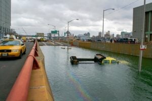
A truck partially submerged amid flooding in New York City following Hurricane Sandy in 2012. Photo: JSJ Creative / Shutterstock.com
New York is not usually the first place people think of when they hear the word hurricane, but history tells a very different story. From early 19th-century hurricanes that pushed water into Lower Manhattan to modern storms that flooded subway tunnels, knocked out power, destroyed coastal neighborhoods, and forced mass evacuations, New York City and Long Island have repeatedly found themselves in the path of dangerous Atlantic weather.
Not every storm on this list was technically a hurricane when it reached New York. Some had weakened to tropical storms or post-tropical systems, while others were powerful nor’easters whose coastal flooding rivaled tropical cyclones. The storms are presented chronologically rather than as a strict damage ranking because historical records become much more complete in the modern era. Together, these 20 events show how wind, storm surge, rainfall, tides, and geography have shaped New York’s long history with coastal storms.
1. The Great September Gale of 1815
Date: September 23, 1815
Storm Type: Severe hurricane that struck Long Island and New England
The Record & Impact: The Great September Gale was one of the earliest major hurricanes documented in the New York and New England region. Because the modern hurricane classification system did not exist, assigning a precise category to the storm is necessarily an estimate.
The Story: The storm struck Long Island before racing into New England, damaging trees, roofs, ships, and waterfront communities across the region. It also became important to the early science of hurricanes. Harvard professor John Farrar compared changing wind directions in New York and Massachusetts and concluded that the storm behaved like a moving vortex rather than a simple straight-line blast of wind. His observations helped lay groundwork for the later understanding that hurricanes rotate around a center.
2. The Great September Gale of 1821
Date: September 3, 1821
Storm Type: Major hurricane affecting the New York City metropolitan area
The Record & Impact: Historical reconstruction places the storm among the most intense hurricanes ever to pass through the New York City area. The storm surge at The Battery has been estimated at about 10 feet, while contemporary accounts reported the East River rising approximately 13 feet in one hour.
The Story: The hurricane moved north at extraordinary speed and passed very near New York Harbor before continuing through Long Island Sound. Lower Manhattan was inundated, with water spreading across the low-lying southern end of the island. The worst outcome was avoided because the peak surge arrived near low tide. Had the same surge coincided with high tide, the flooding would have been substantially worse.
3. The 1893 Hog Island Hurricane
Date: August 24, 1893
Storm Type: Category 1 hurricane at New York landfall
The Record & Impact: The storm struck the New York City area and caused severe damage along the Rockaway shoreline and surrounding coastal communities.
The Story: Hog Island was a barrier-beach resort area off the Rockaways that had developed bathhouses, restaurants, and other summer attractions during the late 19th century. The August 1893 hurricane completely submerged the island and badly damaged its resort structures. Later storms and continued erosion finished what the hurricane had begun, and Hog Island ultimately disappeared beneath the shifting sands and water. The event became one of the most dramatic examples of how quickly New York’s barrier coastline can change.
4. The Great New England Hurricane of 1938
Date: September 21, 1938
Storm Type: Category 3 hurricane at Long Island landfall
The Record & Impact: The hurricane made landfall near Bellport on Long Island with an estimated central pressure near 941 millibars and maximum sustained winds around 120 mph. Storm tides reached approximately 15 feet in parts of eastern Long Island, while New York City recorded major coastal flooding.
The Story: Nicknamed the Long Island Express because of its astonishing forward speed, the hurricane slammed into Suffolk County with very little warning. Westhampton Beach was devastated, Fire Island was cut by new inlets, and the storm created the modern Shinnecock Inlet. Long Island Rail Road tracks were washed out, telephone and power lines fell by the thousands of miles, and about 60 people died on Long Island. New York City experienced powerful winds, falling trees, downed wires, and a major storm tide at The Battery.
5. The Great Atlantic Hurricane of 1944
Dates: September 14-15, 1944
Storm Type: Category 3 hurricane affecting Long Island and the Northeast
The Record & Impact: The storm passed through Long Island as a major hurricane while producing widespread hurricane-force winds, coastal flooding, and heavy seas from the Mid-Atlantic through New England.
The Story: Coastal communities on Long Island experienced wind and water damage, while the hurricane became especially deadly at sea during World War II. Five vessels, including U.S. Coast Guard cutters Bedloe and Jackson, were lost during the storm, contributing to hundreds of maritime deaths along the Atlantic coast. The hurricane remains one of the deadliest wartime weather disasters in U.S. maritime history.
6. Hurricane Carol
Date: August 31, 1954
Storm Type: Category 3 hurricane at Long Island landfall
The Record & Impact: Carol crossed eastern Long Island before striking southern New England. The hurricane produced destructive winds and serious coastal flooding from Long Island northward.
The Story: Long Island’s East End was battered by hurricane conditions as Carol accelerated northward. Trees and utility lines came down, waterfront property was damaged, and coastal communities faced dangerous storm tides. The hurricane was even more destructive in Rhode Island and southeastern Massachusetts, but its Long Island landfall made Carol one of the significant direct hurricane strikes in modern New York history.
7. Hurricane Hazel
Date: October 15, 1954
Storm Type: Fast-moving post-landfall hurricane transitioning as it raced north
The Record & Impact: A peak wind gust of 113 mph was recorded at The Battery in Lower Manhattan, an extraordinary reading for New York City.
The Story: Hazel made its devastating U.S. landfall in the Carolinas before racing north through the eastern United States. By the time its circulation reached New York, the storm was changing character, but its wind field remained exceptionally powerful. Trees, power lines, signs, and building materials were brought down across the metropolitan region. The 113 mph gust reported at The Battery remains one of the most remarkable wind observations in New York City weather history.
8. Hurricanes Connie and Diane
Dates: August 12-19, 1955
Storm Type: Successive tropical cyclones producing major freshwater flooding
The Record & Impact: Connie saturated the ground across parts of New York, and Diane followed only days later. The combined rainfall produced catastrophic flooding in southeastern New York and the Lower Hudson Valley.
The Story: These storms demonstrated that a hurricane does not have to make a direct New York City landfall to produce a major New York disaster. Record flooding struck streams and rivers in southeastern New York. Ellenville was among the communities hit particularly hard, while flooding also affected the Rondout and Wappinger Creek watersheds. The back-to-back storms became one of the great freshwater flood disasters of the 1950s.
9. Hurricane Donna
Date: September 12, 1960
Storm Type: Category 3 hurricane at Long Island landfall
The Record & Impact: Donna crossed Long Island as a major hurricane after a destructive journey from the Caribbean through Florida and up the East Coast. The Battery recorded one of its highest pre-Sandy tropical-storm water levels.
The Story: Donna brought damaging winds, coastal flooding, and major transportation problems to New York City and Long Island. Airports shut down, low-lying roads flooded, and waterfront communities took heavy surf and storm-tide damage. NOAA’s historical tide records show Donna producing one of the highest water levels ever recorded at The Battery before Superstorm Sandy.
10. The Ash Wednesday Storm of 1962
Dates: March 6-8, 1962
Storm Type: Powerful non-tropical nor’easter
The Record & Impact: The slow-moving storm battered the coast through repeated high-tide cycles, creating prolonged flooding and severe beach erosion from the Mid-Atlantic into New York.
The Story: Long Island’s south-facing beaches endured enormous surf and repeated tidal flooding. Dunes, shorefront structures, and barrier beaches were damaged over several days. At The Battery, the storm produced one of the higher extra-tropical water levels in the city’s historical record. Its long duration made it especially destructive because coastal communities were hit again and again rather than by one brief surge.
11. Hurricane Belle
Dates: August 9-10, 1976
Storm Type: Category 1 hurricane at western Long Island landfall
The Record & Impact: Belle made landfall on western Long Island near the Jones Beach-Long Beach area after weakening from major-hurricane strength farther south.
The Story: Coastal residents were evacuated in advance of the storm, and strong winds, flooding, and salt spray damaged property and agriculture across Nassau and Suffolk Counties. The National Hurricane Center’s historical records place Belle’s New York landfall on western Long Island. Although the storm was weaker than feared when it arrived, the massive preparations illustrated how seriously New York had learned to take an approaching hurricane.
12. The March 1984 Nor’easter
Date: March 29, 1984
Storm Type: Major extra-tropical coastal storm
The Record & Impact: Fierce winds, heavy surf, high tides, rain, sleet, and snow produced serious coastal flooding across New York City, Long Island, and the surrounding region.
The Story: Low-lying coastal neighborhoods were flooded and families were evacuated. Sea Gate in Brooklyn was among the areas threatened as bulkheads failed, while evacuations also occurred in Long Island communities. Storm Data records describe a state of emergency in portions of the coastal region, uprooted trees, damaged roofs, power failures, and hundreds of feet of damaged boardwalk. NOAA tide records still list the March 29, 1984 nor’easter among the notable historical coastal-water events around New York Harbor.
13. Hurricane Gloria
Date: September 27, 1985
Storm Type: Hurricane making landfall on western Long Island
The Record & Impact: Gloria’s broad center came ashore on western Long Island between the JFK Airport and Islip areas after racing north along the East Coast.
The Story: Gloria brought widespread tree and utility damage to Long Island and surrounding areas, leaving hundreds of thousands without power across the region. Coastal flooding was significant but was reduced because the strongest surge generally arrived closer to low tide. The storm became one of the most memorable New York hurricanes of the late 20th century and the first major direct tropical-cyclone impact on the area in years.
14. The 1991 Perfect Storm
Dates: October 30-November 1, 1991
Storm Type: Powerful extra-tropical cyclone that absorbed Hurricane Grace
The Record & Impact: The enormous offshore storm generated destructive waves, high tides, beach erosion, and coastal flooding across much of the Northeast shoreline.
The Story: The storm center remained offshore, but its enormous circulation pushed water and waves toward New York’s exposed coast. Beaches and barrier communities on Long Island and around New York Harbor experienced erosion and flooding. NOAA tide records show elevated water levels at The Battery, while the storm’s huge Atlantic waves became famous far beyond New York through the loss of the fishing vessel Andrea Gail.
15. The Great December Nor’easter of 1992
Dates: December 11-12, 1992
Storm Type: Powerful slow-moving extra-tropical coastal storm
The Record & Impact: The storm produced one of the highest pre-Sandy water levels in the modern record at The Battery, reaching approximately 4.65 feet above mean higher high water.
The Story: This storm crippled New York transportation. Three to four feet of water flooded portions of the FDR Drive, the PATH system shut down because of flooding, the Staten Island Ferry was interrupted, bridges closed, and severe flooding struck Broad Channel, the Rockaways, Coney Island, City Island, and other waterfront neighborhoods. The December 1992 nor’easter remains one of the clearest reminders that New York’s worst coastal flooding does not require a tropical hurricane.
16. Hurricane Floyd
Date: September 16-17, 1999
Storm Type: Tropical storm transitioning toward extra-tropical status as it crossed the New York region
The Record & Impact: Floyd’s greatest New York threat was rainfall rather than storm surge. Heavy rain produced serious flooding across southeastern New York, northern New Jersey, Westchester County, and portions of Long Island.
The Story: Central Park set a daily rainfall record of 2.42 inches, while much larger totals fell north and west of the city. Parts of the Belt Parkway, Southern State Parkway, Northern State Parkway, and Long Island Expressway were closed by flooding. Floyd demonstrated how a weakening tropical system can still become a major inland-flooding event in the New York metropolitan region.
17. Hurricane Irene
Date: August 28, 2011
Storm Type: Tropical storm as it crossed New York City
The Record & Impact: Irene produced a roughly 4.5-foot storm surge at The Battery and brought heavy rainfall across the region.
The Story: New York City ordered the first mandatory evacuation of its coastal areas, covering approximately 370,000 residents. The MTA shut down transit service before the storm, and healthcare facilities in vulnerable areas were evacuated. Although New York City escaped the catastrophic surge that had been feared, Irene produced devastating freshwater flooding farther north in New York and across Vermont. The storm became an enormous rehearsal for the far more destructive coastal disaster that arrived the following year.
18. Superstorm Sandy
Date: October 29, 2012
Storm Type: Post-tropical cyclone at landfall in New Jersey
The Record & Impact: Sandy drove record-breaking water into New York Harbor. The Battery recorded a water level roughly 9 feet above mean higher high water, far exceeding earlier modern coastal-flood records.
The Story: Sandy became the defining New York coastal disaster of the modern era. Water poured into Lower Manhattan and flooded subway and vehicular tunnels. Electrical infrastructure failed, neighborhoods along Staten Island, Brooklyn, and Queens were devastated, and the Breezy Point fire destroyed more than 100 homes. New York City recorded 44 deaths and estimated approximately $19 billion in damage and lost economic activity. Staten Island suffered the city’s greatest loss of life, with 24 residents killed.
19. Tropical Storm Isaias
Date: August 4, 2020
Storm Type: Fast-moving tropical storm
The Record & Impact: Isaias brought damaging winds across New York City and surrounding areas, with gusts around 70 mph in the city and widespread tree and utility damage.
The Story: More than 11,000 trees in New York City were reported down or damaged, and nearly 330,000 Con Edison customers lost electricity across New York City and Westchester. Con Edison’s post-storm review described Isaias as the company’s second-largest outage event behind Superstorm Sandy. Queens and Staten Island were especially hard hit because of their extensive overhead power infrastructure.
20. The Remnants of Hurricane Ida
Date: September 1, 2021
Storm Type: Post-tropical remnants interacting with a frontal boundary
The Record & Impact: Central Park recorded 3.15 inches of rain in one hour and 7.13 inches for the day. The National Weather Service issued its first Flash Flood Emergency for the New York City metropolitan area.
The Story: Ida transformed streets, highways, and subway stations into torrents within minutes. Water rushed into basements and below-grade apartments, particularly in Queens and Brooklyn. Thirteen people died in New York City, most in basement housing. The disaster forced the city to rethink extreme-rainfall planning because much of the damage occurred away from the coastal storm-surge zones that had dominated post-Sandy planning.
20 Historic New York Hurricanes and Coastal Storms at a Glance
| Storm | Date | Type at New York Impact | Signature New York Impact |
|---|---|---|---|
| Great September Gale | 1815 | Hurricane | Early major Long Island/New England hurricane |
| Great September Gale | 1821 | Major hurricane | Major Lower Manhattan storm surge |
| Hog Island Hurricane | 1893 | Category 1 | Submerged and devastated Hog Island resort |
| Great New England Hurricane | 1938 | Category 3 | Long Island devastation; Shinnecock Inlet created |
| Great Atlantic Hurricane | 1944 | Category 3 | Long Island impacts and deadly maritime losses |
| Hurricane Carol | 1954 | Category 3 | Eastern Long Island wind and coastal flooding |
| Hurricane Hazel | 1954 | Transitioning/post-landfall cyclone | 113 mph gust reported at The Battery |
| Connie and Diane | 1955 | Successive tropical cyclones | Catastrophic southeastern New York flooding |
| Hurricane Donna | 1960 | Category 3 | Major Long Island strike and NYC coastal flooding |
| Ash Wednesday Storm | 1962 | Nor’easter | Prolonged coastal flooding and erosion |
| Hurricane Belle | 1976 | Category 1 | Western Long Island landfall |
| March Nor’easter | 1984 | Nor’easter | Coastal evacuations, flooding, and wind damage |
| Hurricane Gloria | 1985 | Hurricane | Western Long Island landfall and widespread outages |
| Perfect Storm | 1991 | Extra-tropical cyclone | Coastal flooding and severe beach erosion |
| Great December Nor’easter | 1992 | Nor’easter | FDR, PATH, ferry, and coastal flooding |
| Hurricane Floyd | 1999 | Tropical storm | Major rainfall and inland flooding |
| Hurricane Irene | 2011 | Tropical storm | Mass evacuation and regional flood emergency |
| Superstorm Sandy | 2012 | Post-tropical cyclone | Record storm tide and catastrophic citywide damage |
| Tropical Storm Isaias | 2020 | Tropical storm | Mass tree damage and widespread power outages |
| Remnants of Hurricane Ida | 2021 | Post-tropical remnants | Record hourly rain and deadly inland flash flooding |
For more New York history connected to the places and systems these storms have repeatedly tested, read our History of New York’s Battery Park, Life on the Long Island Expressway, and How to Get Around NYC: 65 Years of Local Advice from a Born-and-Raised New Yorker.
Sources
NOAA Atlantic Oceanographic and Meteorological Laboratory — Great September Gale of 1815
National Weather Service — Hurricane of September 3, 1821
New York City Natural Hazard Mitigation Plan — Historic Coastal Storms
National Weather Service New York — Great New England Hurricane of 1938
National Hurricane Center — Hurricanes in History
U.S. Coast Guard Historian’s Office — Loss of USCGC Bedloe in the 1944 Hurricane
National Weather Service — Hurricane Hazel, October 1954
National Weather Service — Historic Flooding in New York
NOAA Tides & Currents — Historical Water Levels at The Battery
NOAA Weather Prediction Center — Hurricane Belle
NOAA National Centers for Environmental Information — March 1984 Storm Data
National Hurricane Center — 1985 Atlantic Hurricane Season and Hurricane Gloria
NOAA Ocean Prediction Center — The Perfect Storm
National Weather Service New York — December 1992 Nor’easter Coastal Flooding
National Weather Service — Hurricane Floyd Impacts in the New York Region
NYC Emergency Management — Hurricane Irene Response
City of New York — Hurricane Sandy Impacts
Con Edison / City of New York — Tropical Storm Isaias Response Review
National Weather Service New York — Flash Flood Emergency During Ida
City of New York — Hurricane Ida Impacts and Recovery
20 Most Destructive Hurricanes and Coastal Storms in New York History article published on ClassicNewYorkHistory.com © 2026