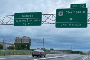
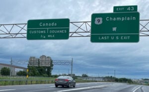
Interstate 87 approaching the Canadian border at Champlain, New York, where the Adirondack Northway continues into Quebec toward Montreal. Photo: James Kirkikis / Shutterstock.com
New York shares 445 miles of international border with the Canadian provinces of Ontario and Quebec. In western New York, the boundary follows the Niagara River and Lake Ontario before continuing through the St. Lawrence River. Farther east, the border becomes a land boundary across the North Country before reaching Lake Champlain.
For travelers, the New York–Canada border is a mix of major international bridges, rural land ports, rail crossings, and marine routes. Some handle heavy commercial traffic around the clock, while others serve mostly local passenger traffic. Several are also undergoing construction or operating under temporary restrictions, so it is important to know which crossing fits the trip you are making.
Travel note: Border hours, NEXUS lanes, construction restrictions, and document requirements can change. Travelers should check U.S. Customs and Border Protection and the Canada Border Services Agency before leaving.
Niagara River Border Crossings
The Peace Bridge — Buffalo to Fort Erie, Ontario: The Peace Bridge crosses the Niagara River between Buffalo and Fort Erie and opened in 1927. Built as a memorial to a century of peace following the War of 1812, it remains one of New York’s most important international routes for passenger vehicles and commercial trucks. Interstate 190 feeds the bridge on the New York side, while the Queen Elizabeth Way is the principal Canadian connection.
The Rainbow Bridge — Niagara Falls, New York to Niagara Falls, Ontario: Opened in 1941, the Rainbow Bridge crosses the Niagara Gorge just downstream from Niagara Falls. Its location makes it the most convenient bridge for visitors moving between the American and Canadian tourist districts. Passenger vehicles, buses, pedestrians, and bicycles may use the crossing, but commercial trucks are not permitted.
The Whirlpool Rapids Bridge — Niagara Falls, New York to Niagara Falls, Ontario: The current Whirlpool Rapids Bridge dates to 1897 and carries traffic on two levels. The lower roadway is restricted to eligible NEXUS travelers, while the upper deck is used for international rail traffic. Amtrak’s Maple Leaf route between New York City and Toronto crosses the Niagara River here.
The Lewiston-Queenston Bridge — Lewiston to Queenston, Ontario: Opened in 1962, the Lewiston-Queenston Bridge connects Interstate 190 and Route 104 with Ontario Highway 405 and the QEW. It carries passenger vehicles, buses, and commercial trucks and is one of the principal freight crossings on the Niagara frontier. Pedestrians are not permitted.
St. Lawrence River International Bridges
The Thousand Islands Bridge System — Alexandria Bay to Ivy Lea, Ontario: The Thousand Islands crossing extends about 8.5 miles from Collins Landing near Alexandria Bay to Ivy Lea near Gananoque, Ontario, linking Interstate 81 with Highway 401. Dedicated in 1938 by President Franklin D. Roosevelt and Canadian Prime Minister William Lyon Mackenzie King, it is not a single bridge but a system of spans. The route includes the large American suspension bridge, the International Rift crossing, and a combination of truss, arch, and suspension spans on the Canadian side.
The Ogdensburg-Prescott International Bridge — Ogdensburg to the Prescott area of Ontario: Completed in 1960, the 1.5-mile bridge crosses the St. Lawrence River from the end of New York State Route 812 to the Canadian side near Johnstown and Prescott. The crossing provides access toward Ottawa as well as Highways 416 and 401 and handles both passenger and commercial traffic.
The Seaway International Bridge — Massena to Cornwall, Ontario: The Seaway International Bridge system links Massena, the Akwesasne Mohawk territory, and Cornwall. The crossing passes through Cornwall Island and remains an important route for residents, passenger vehicles, and commercial traffic moving between northern New York and eastern Ontario.
North Country Land Ports Between New York and Quebec
Champlain / Saint-Bernard-de-Lacolle: Of all the New York–Canada border crossings, this is the one I know best and the one I have used most often. Located about 30 miles north of Plattsburgh, the crossing sits at the northern end of Interstate 87, the Adirondack Northway. Once you enter Quebec, the highway becomes Autoroute 15, which runs directly toward Montreal. For anyone traveling between New York and Montreal by car, this is the principal highway border crossing and one of the busiest international gateways in New York State.
I became very familiar with this crossing when my son was going to college in Plattsburgh. I visited him there often, and since the Canadian border was only a short drive north on the Northway, I would frequently continue up I-87, cross into Quebec, and head over the border just to have lunch. It always struck me how quickly the trip shifted from northern New York to another country. Even after making the drive many times, there was always something special about reaching that large border complex at the end of the Northway and knowing Montreal was less than an hour away.
One of the things that always struck me about Plattsburgh was how close Canada seemed even before you reached the border. Around town, I often saw the Canadian flag flying next to the American flag, something you don’t normally see in most places in New York State. I also remember staying in hotels around Plattsburgh and regularly hearing people speaking French. With Quebec only a short drive north, Canadian visitors were always coming through the area. Those little things constantly reminded me that Plattsburgh was not simply a city in northern New York. It was also a gateway between New York and Quebec. It was a true International City.
The Champlain port operates around the clock and handles both passenger vehicles and a large volume of commercial traffic. On the Canadian side, the Saint-Bernard-de-Lacolle facility is undergoing a major redevelopment, so lane configurations and NEXUS access can change during construction. Travelers heading this way should check current border conditions before leaving, especially on weekends, holidays, and other heavy travel days.
Rouses Point / Lacolle: The Rouses Point land port sits on U.S. Route 11 near Lake Champlain and handles passenger vehicles, commercial traffic, pedestrians, boats, and rail traffic. A replacement U.S. port of entry is now under construction, with work scheduled to continue into 2028. Amtrak’s daily Adirondack between New York City and Montreal also passes through Rouses Point.
Overton Corners / Lacolle Route 221: Overton Corners is a smaller crossing on New York Route 276. It has taken on added importance during the current work at Saint-Bernard-de-Lacolle because Canada has been using Lacolle Route 221 as a temporary NEXUS option while the main Highway 15 NEXUS lane is unavailable.
Mooers / Hemmingford: The Mooers crossing serves local passenger traffic between northern Clinton County and the Hemmingford area of Quebec. The historic U.S. inspection station is one of several New York border facilities built during the early 1930s, when the federal government expanded customs infrastructure in response to automobile travel and Prohibition-era smuggling. CBP lists Mooers as a 24-hour alternative during the Trout River construction project.
Cannon Corners / Covey Hill: Cannon Corners is a low-volume rural crossing in northern Clinton County. Canada selected the crossing for its first land-preclearance pilot in the United States, using a shared facility on the New York side for Canadian processing. Because procedures at this crossing have been changing as the pilot develops, travelers should verify current operations before using it.
Churubusco / Franklin Centre: Churubusco is another small northern New York port. During the Trout River construction project, CBP has listed it as an alternative U.S. port operating from 8 a.m. to 4 p.m. Travelers should confirm current two-way availability before routing through this crossing.
Chateaugay / Herdman: The Chateaugay crossing connects northern Franklin County with the Herdman area of Quebec. During the Trout River closure, CBP lists Chateaugay as an alternative crossing operating from 6 a.m. to 6 p.m. It is also one of the alternate ports accepting commercial traffic.
Trout River / Athelstan: Trout River is currently affected by a major U.S. port-of-entry reconstruction. Since June 1, 2026, the U.S. facility has been closed to southbound traffic entering the United States, while northbound traffic into Canada remains open. The project is expected to continue until approximately May 2028. Travelers entering New York from Quebec should use another crossing while the U.S. facility is closed.
Fort Covington / Dundee: Fort Covington connects New York State Route 37 with the Dundee area of Quebec. Its historic U.S. border station dates to the early 1930s and remains in active use. CBP lists Fort Covington as a 24-hour passenger alternative during the Trout River construction period.
The Cape Vincent–Wolfe Island Ferry Is Currently Closed
For generations, Horne’s Ferry provided a seasonal international route between Cape Vincent in Jefferson County and Wolfe Island, Ontario. That service is not operating in 2026. The ferry stopped running after the 2024 season, and local officials on both sides of the border have been working on plans that could eventually restore the connection. Travelers should not plan on using the Cape Vincent–Wolfe Island route unless service is officially announced as having resumed.
Crossing the Border by Private Boat
Private boaters on the St. Lawrence River, Lake Ontario, and Lake Champlain are also subject to customs reporting requirements. When entering Canada with the intention of landing or disembarking, the boat operator must report to the Canada Border Services Agency through an approved marine reporting procedure. Some locations use the CBSA Telephone Reporting Centre, while others provide in-person service. Boaters returning to the United States from a foreign port or place must also report their arrival to U.S. Customs and Border Protection.
What Identification Do You Need at the New York–Canada Border?
The document rules are not identical in both directions. U.S. citizens entering the United States by land or sea are required by U.S. Customs and Border Protection to present a Western Hemisphere Travel Initiative-compliant document, such as a valid U.S. passport, U.S. passport card, Enhanced Driver’s License, Enhanced Tribal Card, or an eligible Trusted Traveler Program card.
Canada has its own entry rules. For U.S. citizens, the Government of Canada recommends carrying a valid passport because it is the most reliable and universally accepted travel document. U.S. citizens arriving by land or water who do not have a passport may in some circumstances present other documents establishing identity, date of birth, and citizenship. Requirements differ for permanent residents and citizens of other countries, so travelers should confirm their own documentation before the trip rather than assuming the U.S. WHTI rules also govern entry into Canada.
NEXUS, FAST, and Border Wait Times
NEXUS provides expedited processing for pre-approved low-risk travelers at participating crossings, but dedicated lanes are not available everywhere and can move during construction. The Whirlpool Rapids Bridge is especially notable because its lower vehicle deck is reserved for eligible NEXUS traffic. Commercial carriers may also use the FAST program at participating freight crossings when the importer, carrier, shipment, and driver meet program requirements.
Wait times can change quickly on the Peace Bridge, Lewiston-Queenston Bridge, Rainbow Bridge, Champlain crossing, Thousand Islands Bridge, and other busy ports. Construction at Saint-Bernard-de-Lacolle and the temporary restrictions at Trout River make checking official border conditions especially important before a long North Country trip.
For more New York transportation and bridge history, read our 10 Most Iconic Bridges in New York and our History of the Erie Canal.
Sources
New York State Department of Transportation — State Freight Transportation Plan
Niagara Falls Bridge Commission — Which Bridge Do I Take?
Thousand Islands Bridge Authority — History of the Thousand Islands Bridge System
Seaway International Bridge Corporation — Crossing Overview
U.S. General Services Administration — Trout River Land Port of Entry
U.S. General Services Administration — Rouses Point Land Port of Entry
Canada Border Services Agency — Border Wait Times
Government of Canada — What You Need to Enter Canada
U.S. Customs and Border Protection — Documents Needed to Enter the United States
Canada Border Services Agency — Reporting Requirements for Private Boat Operators
Frontenac County — Wolfe Island Travel Information and Horne’s Ferry Status