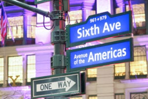
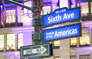
Sixth Avenue and Avenue of the Americas street signs in Manhattan. Photo: GagliardiPhotography / Shutterstock.com
New York City’s grid is a living, breathing historical document, and its street names tell the story of its continuous reinvention. From the winding dirt paths of the original Dutch settlement of New Amsterdam to the late-19th-century real estate campaigns, city officials and prominent developers have often treated street signs as opportunities to reshape the city’s identity. After the American Revolution, New York replaced several street names tied to the British monarchy. A century later, developers promoted more prestigious names for numbered avenues on the Upper West Side to help attract buyers and residents.
Navigating these changes means peeling back layers of asphalt to see the older city beneath. Some of these historic names survive in archival maps and documents, while others remain familiar to New Yorkers who still use the old name long after an official change. Here are 25 New York City streets that changed their names and the political, historical, or economic reasons why.
1. Sixth Avenue to Avenue of the Americas
In 1945, Mayor Fiorello La Guardia officially renamed Sixth Avenue to Avenue of the Americas as a gesture honoring Pan-American unity and the nations of the Western Hemisphere. The city installed decorative medallions bearing the emblems of American nations along the avenue. However, the new name never fully caught on with New Yorkers, who continued calling it Sixth Avenue. During the 1980s, the city’s Department of Transportation began installing Sixth Avenue street signs again alongside the Avenue of the Americas signs. Today, both names are officially recognized, which explains why pedestrians walking through Midtown Manhattan can still encounter signs identifying the thoroughfare as Sixth Avenue.
2. Eighth Avenue to Central Park West
As the Upper West Side developed in the late 19th century, real estate interests recognized the appeal of an address overlooking Central Park. In 1883, the stretch of Eighth Avenue bordering the park was renamed Central Park West. The new name distinguished the avenue from Eighth Avenue farther downtown and advertised its location beside the city’s most famous park. It eventually became associated with some of Manhattan’s best-known apartment buildings, including the Dakota.
3. Ninth Avenue to Columbus Avenue
Similar to Eighth Avenue, Ninth Avenue was associated with the elevated railway and commercial activity farther south. In 1890, the section north of 59th Street was renamed Columbus Avenue in honor of Christopher Columbus. The change came during a period of rapid development and real estate promotion on the Upper West Side. Although the Columbus Avenue name took hold uptown, Ninth Avenue remains the name of the thoroughfare below 59th Street.
4. Tenth Avenue to Amsterdam Avenue
As part of the same 1890 wave of Upper West Side street renaming, Tenth Avenue north of 59th Street became Amsterdam Avenue. The name recalled New Amsterdam, the city’s Dutch colonial predecessor, and gave the growing residential and commercial district a distinct identity. The old Tenth Avenue name survived farther downtown, while Amsterdam Avenue became an established part of the Upper West Side streetscape.
5. Eleventh Avenue to West End Avenue
Real estate developers also wanted to transform the reputation of the western side of the Upper West Side. In 1880, Eleventh Avenue north of 59th Street was renamed West End Avenue. The change was part of a broader effort to promote the neighborhood as the “West End” and distance it from associations with the Bloomingdale area and its institutional past. The name helped give this largely residential avenue a separate identity from Eleventh Avenue to the south.
6. Fourth Avenue to Park Avenue
In the 19th century, Fourth Avenue carried the tracks of the New York and Harlem Railroad, and the smoke and noise of steam trains shaped the street’s character. Railroad improvements gradually moved and enclosed the tracks, allowing landscaped sections to take shape above them. The name Park Avenue was adopted in stages, with the section north of 42nd Street officially renamed in the late 1880s. In 1959, the stretch of Fourth Avenue between 17th and 32nd Streets became Park Avenue South. A shorter section of Fourth Avenue still retains its original name near Union Square.
7. Crown Street to Liberty Street
Following the American Revolution, newly independent New Yorkers wanted to remove reminders of British colonial rule. Crown Street, which had been laid out in Lower Manhattan during the colonial era, was renamed Liberty Street in 1794. The new name expressed the political ideals of independence rather than loyalty to the monarchy. It remains one of the clearest examples of the revolutionary period’s influence on the city’s street map.
8. King Street to Pine Street
Part of the same post-Revolutionary effort, King Street in Lower Manhattan was renamed Pine Street in 1794. The old name carried an unmistakable royal association, while the replacement fit the neighborhood’s collection of street names drawn from trees and other familiar features. The change was one of several that removed references to the British crown from the city’s public geography.
9. Little Queen Street to Cedar Street
Little Queen Street was another casualty of the postwar campaign to remove royal references. The Lower Manhattan street became Cedar Street in 1794, exchanging a name associated with monarchy for one drawn from nature. Along with the renaming of Crown and King Streets, the change demonstrated how the city’s political identity was being rewritten directly onto its street signs.
10. Partition Street and Fair Street to Fulton Street
What we now know as Fulton Street was once divided into two streets at Broadway. Partition Street ran west of Broadway, while Fair Street continued east toward the East River. During the early 19th century, the two names were replaced by Fulton Street in honor of Robert Fulton, whose steamboat ventures helped transform transportation on the Hudson River and beyond. Historical accounts differ on the precise year of the combined renaming, but the new name became a lasting tribute to a figure closely associated with New York’s maritime development.
11. Chatham Street to Park Row
Originally named in honor of William Pitt, the Earl of Chatham, Chatham Street became an important Lower Manhattan thoroughfare. By the late 19th century, the section bordering City Hall Park was closely associated with the city’s newspaper publishers and printing businesses. It was officially renamed Park Row in 1886, reflecting its position beside the park. The street and its surrounding blocks became widely known as Newspaper Row because of the concentration of publishing companies operating there.
12. Brouwer Straat to Stone Street
During the Dutch era of New Amsterdam, part of today’s Stone Street was called Breuers Straet, or Brewers Street, later rendered as Brouwer Straet, because of breweries located along the road. In 1658, residents had the street paved with stone, making it one of the colony’s earliest paved thoroughfares. After the English takeover, the western section became known as Stony Street, and the present Stone Street eventually incorporated other old street segments as well. Its historic paving and narrow course still recall the city’s colonial beginnings.
13. Heere Gracht to Broad Street
Before it was a street, the route of today’s Broad Street contained a canal. The Dutch called it the Heere Gracht, or Gentlemen’s Canal, after the waterways of Amsterdam. As New Amsterdam grew, the canal became increasingly difficult to maintain and was used for drainage and waste. English authorities filled it in during 1676, leaving a notably broad thoroughfare in its place. The name Broad Street preserves a trace of that unusual colonial landscape.
14. Art Street to Astor Place
In the early 19th century, a section of an older route linking the Bowery with the roads leading toward Greenwich Village was known as Art Street. Following the death of John Jacob Astor in 1848, the street became Astor Place. Astor had made an enormous fortune in the fur trade and New York real estate, and his family was closely associated with development in the surrounding area. The new name preserved his place in the city’s history even as the neighborhood changed around it.
15. Asylum Street to West 4th Street
In the early 1800s, a Greenwich Village roadway was named Asylum Street because the Orphan Asylum Society operated an institution nearby. In 1833, the street became part of West 4th Street as the city’s numbered street system was extended and older local names were replaced. Its unusual route helps explain one of Manhattan’s famous geographical puzzles: West 4th Street eventually turns north and intersects West 10th, West 11th, and other higher-numbered streets.
16. Amity Street to West 3rd Street
Amity Street was another older Greenwich Village thoroughfare that lost its distinctive name as the neighborhood’s street network was brought into the numbered system. It became West 3rd Street, although the old name survived for years in property records and historical accounts. The change illustrates how the rigid numbering familiar across much of Manhattan was imposed on parts of Greenwich Village that had developed along an entirely different pattern.
17. Monument Lane to Greenwich Avenue
Originally, this was part of a winding country route leading north and west from the older city. It became known as Monument Lane because it led toward a monument honoring British General James Wolfe, remembered for his victory at Quebec. The monument disappeared, but sections of the road survived as the city expanded. Today’s Greenwich Avenue follows part of that earlier route, preserving the course of a street that predates Manhattan’s familiar numbered grid.
18. Petticoat Lane to Marketfield Street
This short, easily missed Financial District street had several names over the centuries. Its present name, Marketfield Street, derives from the Dutch Marcktveldt, a livestock market once located near what is now Bowling Green. During the colonial and early American periods, the lane also appeared under names including Exchange Street, Fieldmarket Street, and Petticoat Lane. Its changing names offer a glimpse of a time when Lower Manhattan’s narrow roads were tied directly to local markets and everyday commerce.
19. Tin Pot Alley to Exchange Alley
Exchange Alley is a narrow passage in the Financial District with a long list of former names. Its Dutch-era name, Tuyn Straet, became Garden Street in English, but the alley was also known as Tin Pot Alley, Edgars Alley, and Oyster Pasty Alley. The present name is associated with the Merchants’ Exchange, whose original building opened in 1827 and was destroyed in the Great Fire of 1835. The alley’s unusual history survives in a part of Manhattan where most streets are overshadowed by much taller buildings.
20. Hoffman Boulevard and Thomson Avenue to Queens Boulevard
In the early 20th century, as Queens prepared for increasing traffic following the opening of the Queensboro Bridge, city planners widened and joined older routes to create Queens Boulevard. Thomson Avenue served the western portion of the corridor, while Hoffman Boulevard continued farther east. Their transformation into a wide arterial boulevard helped connect Long Island City, Elmhurst, Forest Hills, and neighborhoods farther east. Small remnants of the earlier road alignments and names still survive in Queens.
21. Central Avenue to Jerome Avenue (The Bronx)
The Bronx road that became Jerome Avenue was originally known as Central Avenue, a route connecting the Macombs Dam Bridge area with the Jerome Park Racetrack. It was eventually named for financier Leonard W. Jerome, who helped establish the racetrack and was Winston Churchill’s maternal grandfather. One frequently repeated account says that a member of the Jerome family paid for bronze street signs after officials considered another name, sometimes recorded as Murphy Avenue. Versions of the story differ on who arranged the signs, so the anecdote is best treated as a local historical tradition rather than a settled fact. And one fun fact: the best donuts I ever had were on the corner of Jerome Avenue and W Mosholu Parkway S.
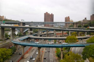
22. The Harlem River Speedway to Harlem River Drive
When this route along the Harlem River opened in 1898, it was called the Harlem River Speedway. It was initially reserved for horseback riders and drivers of horse-drawn carriages, excluding many other road users. As automobiles became part of New York life, the road opened to motorists in 1919 and was paved in 1922, when it became known as the Harlem River Driveway. Later highway construction incorporated portions of the old speedway into the modern Harlem River Drive, transforming a recreational carriage route into a major traffic corridor.
23. Avenue A to York Avenue
On Manhattan’s Upper East Side, the stretch of Avenue A north of East 59th Street was renamed York Avenue in 1928 to honor Sergeant Alvin C. York, one of the most celebrated American soldiers of World War I. The new name replaced part of the lettered avenue system established as Manhattan developed northward. Unlike many streets named for New York politicians, property owners, or developers, York Avenue commemorates a nationally known military figure whose service had become famous across the country.
24. Robinson Street to Park Place
In the early 19th century, the Lower Manhattan street now called Park Place was known as Robinson Street. Historical records place the change to Park Place in 1813. The new name referred to its proximity to the public grounds that became City Hall Park. As the surrounding neighborhood developed into a center of commerce, government, and publishing, Park Place became one of the familiar street names of the civic district.
25. West 59th Street to Central Park South
In 1896, the stretch of West 59th Street bordering Central Park, between Columbus Circle and Grand Army Plaza, acquired the name Central Park South. The change gave the park-facing blocks an identity closely tied to their location and to the hotels and apartment buildings developing there. The street is still understood as part of the 59th Street corridor, but Central Park South remains the familiar name for the section along the southern edge of the park.
For more on the history behind New York City’s changing streets and neighborhoods, read our articles on How Manhattan Neighborhoods Got Their Names, How Bronx Neighborhoods Got Their Names, and 10 Things That Disappeared From New York City Street Corners.