Photo by Anthony Quintano, via Wikimedia Commons, licensed under CC BY 2.0. Cropped from original.
There are winter storms that Upstate New Yorkers remember by their dates, and others they remember by what happened afterward. Someone who lived through Buffalo’s Blizzard of 1977 may still recall the sound of wind against the windows or the sight of a car disappearing beneath a drift. Families in the Southern Tier remember nights when the snow rose faster than plows could clear it. In the Hudson Valley, a heavy snowfall sometimes meant something different altogether: tree limbs crashing into power lines, darkened houses, and roads that looked familiar until the snow took away every recognizable landmark.
New York’s geography gives winter weather several ways to become dangerous. Cold air crossing the relatively warmer waters of Lakes Erie and Ontario can produce narrow bands of lake-effect snow that bury one neighborhood while another, just a few miles away, receives only a few inches. Along the Hudson and in the Catskills, powerful coastal storms can spread heavy snow over broad areas. The Adirondacks, Tug Hill, Mohawk Valley, and Southern Tier face their own combinations of elevation, cold, wind, and difficult travel. The deepest snowfall is not always the deadliest storm; wind, timing, and the condition of roads and buildings can matter just as much.
For generations, those storms have interrupted ordinary New York lives. Schools became shelters, neighbors checked on neighbors, snowplows needed rescuing, and families discovered that a short drive could become an overnight ordeal. The memories are especially strong when bad weather arrived during holidays or before winter had properly begun. A storm in October could devastate trees still carrying their leaves. One in April could catch communities already preparing for spring. And sometimes an event lasted so long that the next snowfall began before the previous one had been cleared.
The following 25 storms are not presented as a scientific ranking of the state’s largest snow totals. They are a documented selection of events with remarkable histories and consequences. Some are part of living memory; earlier storms, including the Blizzard of 1888, survive through weather records and accounts handed down over generations. Snowfall amounts refer to the particular place and measurement period identified, not to an entire region. Where a storm dropped more than one kind of precipitation, the focus here remains on its significant snowfall rather than treating a primarily freezing-rain disaster as a snowstorm.
1. The Blizzard of 1977 — Buffalo and Western New York
On January 28, 1977, a brutal front swept across Buffalo and turned a difficult winter into a disaster. This was not simply a case of unusually heavy snow falling from the sky. Lake Erie was frozen, the city already had a deep snowpack, and powerful winds lifted loose snow from the ice and open ground. At Buffalo’s airport, wind gusts reached 69 miles per hour; at Niagara Falls, they reached 75. Visibility plunged to near zero as streets filled with blowing snow and drifts. The blizzard continued to affect the region into February 1.
Thousands of people were stranded in cars, workplaces, and buildings they never intended to spend the night in. Some vehicles disappeared beneath snowdrifts, and emergency crews struggled to reach people who needed help. The National Weather Service attributes 29 deaths to the storm. President Jimmy Carter declared a federal disaster, an extraordinary moment in the city’s weather history. Older Buffalo residents can still identify this as ‘the Blizzard of ’77’ without needing another explanation; the phrase immediately brings back a particular week, not merely an impressive snowfall total.
2. The Christmas Blizzard of 2022 — Buffalo and the Niagara Frontier
The storm that struck Western New York on December 23, 2022, brought the worst possible combination of weather and timing. Many people were traveling or preparing for Christmas when winds intensified, temperatures plunged, and heavy lake-effect snow swallowed the Buffalo metropolitan area. The National Weather Service documented 37 consecutive hours of blizzard conditions on December 23 and 24, with gusts exceeding 70 miles per hour. Snowfall from the broader December 23–27 event exceeded 50 inches at Buffalo’s airport, but the nearly continuous whiteout and dangerous cold made it far more than a contest over snow depth.
People became trapped in vehicles and homes, while first responders themselves were stopped by the conditions. Power failures made the extreme cold more threatening. The National Weather Service’s 2026 account identifies 47 deaths across Erie and Niagara counties associated with the storm. The disaster raised urgent questions about travel bans, public warnings, shelter access, and what emergency services can do when roads are physically impassable. For many Western New Yorkers, the experience of that Christmas weekend is still too recent to feel like distant history.
3. The Storm of the Century — March 1993
From March 12 to 14, 1993, an enormous storm system swept through the eastern United States, producing destructive weather far beyond New York. Upstate residents remember its northern side: deep snow, tremendous winds, stalled vehicles, and neighborhoods that seemed to vanish beneath the accumulation. Albany recorded 26.6 inches of snow, while communities in the Catskills reported even more. The National Weather Service lists 40 inches at Halcott Center and 36 at Prattsville. Snowfall rates reached several inches per hour in the most intense bands.
The storm’s immense geographical reach set it apart from narrow lake-effect events. It interrupted travel across eastern and central New York and prompted emergency declarations as officials faced simultaneous problems over a vast area. Families who had experienced other heavy winters still found the combination of intensity and wind remarkable. The storm became a reference point for everything that followed: when a new nor’easter was forecast, people compared it to March 1993. Its reputation remains national, but its history is also deeply rooted in Upstate towns and cities.
4. Snowvember — The Buffalo Lake-Effect Storms of November 2014
On the evening of November 17, 2014, a lake-effect band settled over communities south and east of Buffalo and barely moved. In parts of southern Cheektowaga, Lancaster, and West Seneca, snow accumulated at astonishing rates; other neighborhoods just a short drive away had only modest totals. The National Weather Service measured as much as 65 inches during the first major event of November 17–19. A second lake-effect storm from November 19–21 struck many of the same locations and pushed combined totals toward seven feet in the hardest-hit areas.
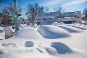
The storm’s sharp boundaries made for unforgettable images: a wall of snow on one side of a road, clearer skies on the other, and homes surrounded by towering banks of freshly fallen snow. Roads closed, people were stranded, and the weight of snow contributed to roof failures. At the same time, emergency workers and neighbors confronted the exhausting reality of moving several feet of snow before another band arrived. The nickname ‘Snowvember’ captured both the surprise of the timing and the extraordinary local concentrations. It also demonstrated why one citywide snowfall figure cannot adequately describe a lake-effect disaster.
5. The Great Blizzard of 1888 — Albany and the Upper Hudson Valley
The Blizzard of March 11–14, 1888, belongs to history rather than living memory, but Albany’s weather record keeps its scale unmistakable. Snow began during the afternoon of March 11 and intensified into a prolonged siege. By the time it ended early on March 14, 46.7 inches had accumulated in Albany, according to the National Weather Service. It remains the city’s largest recorded storm snowfall. Drifts were even deeper, and the transportation and communication systems of the nineteenth century were poorly equipped to deal with the consequences.
Coal deliveries stopped, leaving homes without dependable heat. Doctors struggled to reach patients, while country roads took days to reopen. The disruption extended well beyond one city’s boundaries as the storm paralyzed much of the Northeast. It is tempting to tell this story simply as an early version of a modern snow emergency, but the absence of contemporary machinery, forecasting, and communication made the experience profoundly different. The Blizzard of 1888 explains why old newspaper accounts of New York winters often treated a major storm as a threat to the basic functioning of everyday life.
6. The Blizzard of 1966 — Oswego, Rome, and Central New York
From January 29 through 31, 1966, a major coastal storm was followed by intense lake-effect squalls off Lake Ontario. The heaviest snow did not fall evenly across Upstate New York. According to the National Weather Service, Oswego reported 75 inches, with still higher unofficial estimates in the surrounding area. Rome, well inland from the lakeshore, reported 41 inches. Albany received roughly a foot from the larger storm system, illustrating how dramatically conditions varied across the state.
The lake-effect portion of the storm created the images that linger in Central New York memory: roads swallowed by drifts, travel brought to a standstill, and crews facing a volume of snow that could not be moved quickly. The National Weather Service’s historical account distinguishes the heavy coastal snow from the even more remarkable squalls that developed afterward. That distinction matters, because calling this a single uniform ‘100-inch Syracuse blizzard’ misplaces the greatest snowfall and erases the particular ordeal of Oswego and nearby communities.
7. The October Surprise — Buffalo, October 2006
On October 12 and 13, 2006, Buffalo experienced the kind of snowfall that can do more damage in autumn than a larger storm in midwinter. Cold air crossing Lake Erie generated an intense band of heavy, wet lake-effect snow while many trees still carried their leaves. The official Buffalo airport total reached 22.6 inches, and areas around Depew and Alden reported approximately 24 inches. The snow was accompanied by thunder and lightning, making the scene even stranger for residents who had not yet put away their summer equipment.
Branches and entire trees collapsed under the weight, pulling down utility lines and damaging homes and cars. The National Weather Service reported more than 400,000 utility customers losing power, with full restoration taking nearly two weeks. Schools closed and the Thruway became impassable in places. The October timing complicated the response: public works departments were still handling autumn maintenance, while communities confronted a major winter emergency. The event entered Buffalo history not only because of the snowfall but also because its effects were magnified by trees, leaves, and the season.
8. The Nine-Day Lake-Effect Siege — Tug Hill, February 2007
Between February 3 and 12, 2007, bands of lake-effect snow repeatedly targeted communities east of Lake Ontario. On the Tug Hill Plateau, an area famous for substantial winter snow, the totals were extraordinary even by local standards. The National Weather Service verified 141 inches at Redfield over the ten-day period. Parish reported 121 inches, while Mexico and North Osceola each recorded more than 100. These figures belonged to an extended episode of recurring snow bands, not to a single 24-hour snowfall.
Roofs came under heavy strain, travel became difficult, and residents spent days clearing driveways only to find them buried again. New York declared disaster areas in Oswego and Lewis counties. The National Weather Service cautioned against calling the ten-day total a one-storm record because snowfall measurements over different durations cannot be compared directly. That careful distinction does not diminish what residents endured. The event remains one of the defining stories of life in the lake-effect snowbelt, where the duration of a winter pattern can matter as much as its peak intensity.
9. The Pi Day Blizzard — Binghamton and the Southern Tier, March 2017
March 14, 2017, became a date Southern Tier residents did not need help remembering. A powerful nor’easter spread snow into Central New York and the Binghamton area, concentrating its heaviest precipitation in an intense band. At Greater Binghamton Airport, 31.3 inches fell in a roughly 24-hour period beginning early on March 14, breaking the previous 24-hour snowfall record there. The National Weather Service documented storm totals across its forecast area ranging from about eight inches to more than 30.
The combination of rapid accumulation and strong winds made routine travel nearly impossible. Streets, parking lots, and residential driveways had to be cleared repeatedly, and the work took longer than many residents had expected for a March storm. The nickname ‘Pi Day’ came from the date, 3/14, but the snow gave the phrase an entirely different meaning to people in Broome County. Because records at the local airport extend back to the early 1950s, the measured total provides a solid historical comparison rather than simply an impression that the storm was unusually big.
10. The December 2020 Nor’easter — Greater Binghamton
The snow began on December 16, 2020, and rapidly intensified overnight. A narrow but remarkably productive band settled over the Southern Tier, dropping snow faster than plows could remove it. The official storm total at the National Weather Service office near Binghamton was 40.0 inches, with several nearby communities reporting similar or slightly higher amounts. Forecasters documented snowfall rates reaching four to six inches per hour during the most intense period on December 17.
Those rates explain why the storm was so disruptive. Roads became almost impassable in hours, and even snowplows sometimes became stuck. Neighbors woke to vehicles nearly submerged and sidewalks that required more than an ordinary shovel. The storm was not equally severe everywhere in New York; its defining feature was an exceptionally heavy snowband over a comparatively narrow area. For the Binghamton region, it became a new benchmark alongside the March 2017 blizzard, demonstrating that the Southern Tier can experience extreme snowfall without relying on Lake Erie or Lake Ontario for lake-effect snow.
11. The Christmas Week Lake-Effect Storm — Buffalo, December 2001
Long before the Christmas Blizzard of 2022, another Western New York holiday was overwhelmed by snow. From December 24 through 29, 2001, lake-effect bands repeatedly shifted across the Buffalo area, bringing intense snowfall, thunder, and travel emergencies. The National Weather Service lists 81.6 inches at Buffalo Airport for the event, with heavy totals extending into suburbs such as West Seneca and Lancaster. Some communities were buried for days while snowfall remained far lighter outside the persistent bands.
Driving bans, states of emergency, and National Guard assistance became part of the holiday week. Crews came from other cities to help clear the accumulated snow, and the weight of the snow caused structural damage, including roof collapses. In the middle of what might otherwise have been family visits and holiday errands, residents instead faced days of digging, waiting, and checking on others. The date is an important correction to the original outline: this was a Christmas-week lake-effect disaster, not a Thanksgiving 2001 storm.
12. The ‘Six-Pack’ Blizzard — Buffalo, January 1985
Buffalo’s next famous blizzard after 1977 arrived January 19–22, 1985. Snow squalls, high winds, and plunging temperatures combined to produce whiteouts and dangerous wind chills across Western New York. The storm dropped 34.4 inches over four days at Buffalo, according to a Buffalo State historical weather review. Cars were abandoned on streets and highways, emergency shelters opened, and widespread travel restrictions followed. At times, the wind turned even moderate snowfall into blizzard conditions by constantly moving snow across roads.
Mayor Jimmy Griffin became part of the storm’s folklore when he urged residents to remain at home with a six-pack and watch football. The quote helped give the event its enduring nickname. The humor should not obscure the danger: temperatures were bitterly cold, snowdrifts reached several feet, and public officials faced an emergency across multiple counties. Many people who lived through both 1977 and 1985 remember the contrast between the two: the earlier storm was notorious for its immense ground blizzard, while the later one combined substantial new snow with severe cold and wind.
13. The Rochester Blizzard — March 1999
Rochester’s weather history includes a particularly memorable early-March episode in 1999. On March 4, heavy snow and strong winds hit the city hard enough to close sections of the New York State Thruway and strand motorists. The National Weather Service recorded 22.3 inches of snow in Rochester that day. The National Guard assisted in removing stranded vehicles, and power interruptions affected more than 10,000 customers across the area. This was a storm felt not only at home but by commuters and travelers who suddenly had nowhere safe to go.
Before the area could finish cleaning up, another storm brought significant snow around March 6. Rochester was among the places reporting heavy additional accumulation, making the first week of March an exhausting stretch. The overlap is why photographs of that winter sometimes show piles much higher than the amount from any one day. The region’s experience also deserves separate attention from Buffalo’s better-known snow history: Rochester residents faced a major combination of snow, wind, stranded vehicles, and repeated cleanup in their own communities.
14. The November 2022 Lake-Effect Wall — Buffalo’s Southtowns
Only weeks before the Christmas blizzard, Western New York endured another remarkable lake-effect event. Between November 16 and 20, 2022, an intense snowband repeatedly targeted southern suburbs of Buffalo. The Northeast Regional Climate Center at Cornell University reported preliminary measurements of 81.2 inches west of Hamburg and 80 inches in Orchard Park, with nearby Blasdell and Hamburg also receiving exceptionally heavy totals. Downtown Buffalo and communities north of the most persistent bands received much less, a familiar but still astonishing feature of lake-effect snow.
Road closures and emergency declarations disrupted travel, and the New York State Thruway was closed across parts of Western New York. The snowfall also reached areas east of Lake Ontario. A few weeks later, December’s lethal blizzard changed the way many people remembered the winter, but the November storm deserves its own place in the record. It was a distinct event, with a distinct pattern and a different set of local impacts. For residents in the Buffalo Southtowns, the winter of 2022 began with a six-foot-plus emergency before Christmas was even in sight.
15. The December 1995 Lake-Effect Storm — Buffalo
During December 9–11, 1995, a persistent lake-effect snowband put Buffalo and its northern and eastern suburbs under extraordinary strain. Snow fell at rates of two to four inches per hour in the strongest periods. The National Weather Service described more than two feet falling in about eight hours in parts of the city and nearby communities. Snow totals changed sharply over short distances, in places dropping by as much as 30 inches within only a few miles. Drivers who escaped the heaviest band could find vastly different conditions almost immediately.
The quick accumulation overwhelmed plowing efforts and brought the metropolitan area to a standstill for days. Emergency declarations spread across Buffalo, Lancaster, Depew, Cheektowaga, and other parts of northern Erie County. Snow history in Western New York is sometimes reduced to the famous years of 1977 and 2022, but longtime residents remember many other events that could shut down their community. December 1995 belongs in that conversation because its sharp snowfall gradient and extreme short-term intensity were unmistakable examples of the region’s lake-effect climate.
16. The Post-Christmas Blizzard of 1969 — Albany and the Capital Region
Albany had already seen significant snow in December 1969 when another powerful storm developed on Christmas night. From December 25 through 28, heavy snow spread across the Capital Region, and the storm slowed near the New England coast. Albany recorded 26.7 inches, according to the National Weather Service. The snow was heavy and wet at times, with periods of freezing rain mixed in. The winter landscape became increasingly difficult as another large accumulation arrived on top of what had fallen earlier that month.
The long cleanup was part of what made this storm unforgettable. The National Weather Service reports that some streets were not cleared for three to four weeks and that Albany public works operations continued around the clock for more than a month before conditions approached normal. Snow removal costs reached a then-record level. While people elsewhere might remember 1969 for national events, older Capital Region residents had their own distinct December memory: a holiday storm whose consequences remained long after the falling snow had stopped.
17. The Thanksgiving Snowstorm of 1971 — Albany, Catskills, and Upper Hudson Valley
The day before Thanksgiving is supposed to be one of the busiest travel days of the year, and November 24, 1971, was no exception. Unfortunately, a major winter storm was arriving at the same time. Heavy snow continued into Thanksgiving Day, striking the Catskills and Upper Hudson Valley. Albany recorded 22.5 inches, while some locations elsewhere in the region reported as much as 30 inches. This was an exceptionally early heavy snowfall for eastern New York, rather than a routine midwinter event.
Travelers who had set out for holiday gatherings became stranded or failed to reach their destinations. Snow crews faced the task of clearing highways at precisely the moment when the roads would normally have been filled with visiting families. The National Weather Service identifies the event as one of Albany’s greatest November storms. Its story is not only about the depth of the snow but also about timing. A severe storm can change the memory of a holiday forever, and for many families the Thanksgiving of 1971 became the year travel plans were replaced by snowbanks and waiting.
18. The February 1958 Blizzard — Catskills and Eastern New York
A coastal storm on February 15 and 16, 1958, spread heavy snow and strong winds across eastern New York and neighboring New England. Albany measured 17.9 inches, while parts of the Catskills reported more than 30 inches. Blowing and drifting snow blocked roads, leaving travelers and rural residents cut off. The combination of snow depth and inaccessible routes was especially troublesome in agricultural communities, where animals still needed feed even when roads could not be cleared in time.
The National Weather Service preserves a remarkable detail from the response: Operation Haylift, during which helicopters delivered feed to stranded cattle. That image tells us something important about the era. Snowstorms were not only urban transportation stories; in rural Upstate New York, farmers had to protect livestock and keep essential work going regardless of the weather. The 1958 event shows how an extended snow emergency could spread from highways into the daily operations of farms and small towns, turning aviation equipment into an unexpected lifeline.
19. The April Blizzard of 1982 — Albany and Eastern New York
Early April is when many Upstate residents begin to expect relief from snow. On April 6 and 7, 1982, winter delivered the opposite. A powerful system brought heavy snow, strong winds, and even thunderstorm activity to eastern New York. Albany recorded 17.7 inches, making it the city’s greatest April snowstorm in the National Weather Service historical record. Many locations across the forecast area received one to two feet, and the storm shut down schools, offices, and highways.
The timing made it particularly disruptive. People were no longer planning their days around the possibility of a major blizzard, but plows and road crews had to return to full winter operations. Strong winds created drifting that made the snowfall harder to manage. The storm is a reminder that New York’s winter calendar does not follow a neat schedule: a snow event that would be serious in January can feel almost unbelievable when it arrives after the first signs of spring. For the Albany area, April 1982 remains an enduring example.
20. The December 1992 Mountain Snowstorm — Catskills and Helderbergs
A storm on December 10–12, 1992, illustrated how elevation and wind direction could produce radically different weather only a short distance apart. Strong easterly winds forced moisture up mountain slopes while leaving some valley areas comparatively dry. Across the Catskills and Helderbergs, the National Weather Service reported 18 to 39 inches of snow; parts of the nearby Berkshire Mountains received even greater totals. In Albany itself, only about six inches fell, with much of that arriving late in the event.
The contrasts surprised travelers who expected a storm to affect the region uniformly. Schools closed for days in some communities, and heavy equipment was needed to reopen roads. A person driving from the Capital District into higher ground could move from manageable conditions into an altogether different emergency. The storm belongs on this list because it demonstrates something essential about Upstate weather: a valley’s snow measurement can conceal a severe mountain disaster. It also foreshadowed the exceptionally snowy winter that culminated in the March 1993 superstorm.
21. The Christmas Day Nor’easter of 2002 — Albany and the Hudson Valley
Christmas 2002 brought a large nor’easter to eastern New York. The storm developed along the Atlantic Coast and pushed heavy snow inland on December 25 and 26. Albany recorded approximately 21 inches, with blowing and drifting conditions that disrupted travel just as people were trying to visit relatives or return home. The New York State Thruway closed along a long section between Catskill and Syracuse, while airline passengers were stranded after flights were canceled at Albany International Airport.
The snowfall was memorable on its own, but residents did not get a lengthy recovery period. Another major storm arrived in early January, leaving two separate snowfalls above 20 inches at Albany in one winter. The National Weather Service emphasizes how unusual that sequence was in the local record. Families who remember Christmas 2002 often remember the follow-up storm as well, because the work of digging out and restoring travel seemed to begin all over again. That holiday week set the stage for a demanding winter.
22. The New Year’s Nor’easter — Albany, January 2003
From January 3 to 4, 2003, another powerful coastal snowstorm reached the Capital Region only days after the Christmas Day nor’easter. Albany received 20.8 inches, according to the National Weather Service. Snowfall and strong winds complicated the cleanup from the previous storm, and ice left on trees from freezing rain earlier in the week made falling limbs and utility disruptions a larger concern. A major winter event is hard enough when streets are clear; this one struck with the earlier snow still shaping daily life.
The two storms together turned the winter of 2002–03 into one of Albany’s snowiest on record. Keeping the Christmas storm and the January storm separate is more accurate than blending them into one vaguely defined holiday disaster: they had different dates, different snowfall measurements, and distinct rounds of disruption. For residents, however, the emotional experience could feel continuous. Once the latest forecast arrived, the question was not merely how much snow might fall but where the city would put it after another round of plowing.
23. The Halloween Nor’easter of 2011 — Hudson Valley and Catskills
On October 29 and 30, 2011, wet snow spread across the Hudson Valley, Catskills, and parts of eastern New York while autumn leaves still clung to many trees. In the higher elevations, the storm produced much heavier accumulations than in lower valleys; the National Weather Service reported roughly 10 to 16 inches in the eastern Catskills and up to around two feet in parts of the Taconic region. Albany recorded a comparatively modest total, another example of the dramatic differences between neighboring areas.
The trees became the central problem. Leaves and branches loaded with wet snow snapped, taking power lines down and damaging property. Thousands of households across the wider Northeast faced extended outages, and local communities dealt with blocked roads and canceled plans at a time when children were expecting Halloween celebrations. This was not a classic midwinter powder storm. It was a clash between a winterlike weather system and an autumn landscape, producing damage out of proportion to the snowfall measurements in some locations.
24. The February 2014 Storm — Capital Region, Catskills, and Mohawk Valley
The winter of 2013–14 was already wearing on many Upstate residents when another major system arrived February 12–14. Heavy snow moved across the Capital Region, Lake George-Saratoga area, Schoharie Valley, Catskills, and neighboring regions. The National Weather Service documented widespread totals of one to two feet, with 14.4 inches at Albany International Airport. Heavy bands at times produced several inches of snow per hour, followed by gusty winds that blew snow back across recently cleared roads and driveways.
One of the most frustrating details of the event was the sequence: a resident could shovel the driveway after the heavy snow, go to bed, and wake to find drifting had undone the work. Roofs and public infrastructure were already dealing with earlier winter accumulation, and some buildings suffered under the added weight. The storm did not claim a unique nickname comparable to ‘Snowvember,’ but it reflects another kind of Upstate winter memory—the exhausting stretch when the next storm arrives before a community has recovered from the last one.
25. The Back-to-Back February Storms of 2010 — Eastern Catskills and Hudson Valley
During February 23–27, 2010, eastern New York faced two closely spaced storms that combined heavy snow with damaging weather. The first round brought generally one to two feet to parts of eastern New York and western New England, with the greatest accumulations at higher elevations. A second storm soon followed, producing additional heavy, wet snow in some areas and heavy rain elsewhere. In portions of the Catskills and Hudson Valley, the result was a difficult mix of fallen trees, interrupted transportation, and widespread outages.
The National Weather Service documented blocked roads, building damage, and disruptions to Amtrak service between Albany-Rensselaer and Poughkeepsie. Power lines already stressed by the first storm faced another round of heavy precipitation and falling branches. This entry recognizes a connected late-February emergency, rather than inventing a single enormous snowfall total for the whole week. Residents remember the sequence because there was little opportunity to finish cleaning up before the next system arrived, particularly in the higher terrain where snow and trees made access difficult.
Why These Upstate Snowstorms Are Still Remembered
What makes these snowstorms memorable is not simply how high a measurement climbed. The Blizzard of 1977 became synonymous with wind and immobilizing drifts; Snowvember showed how lake-effect bands could divide adjacent neighborhoods into two different worlds. Eastern New York’s great coastal storms disrupted travel across broad areas, while early-season events in 2006 and 2011 reminded communities that even a smaller accumulation can be destructive when it lands on trees still carrying leaves.
The storm records also show why local details matter. Buffalo’s snowfall cannot be substituted for Oswego’s, and an airport measurement does not describe every home in a county. In some places the greatest danger came from blinding wind or failed heat, in others from roof loads, stranded vehicles, or farms cut off from supplies. The stories of people checking on neighbors, opening shelters, and working through days of cleanup belong to the history just as much as the numbers do.
For a look at a different part of the state, see our 12 Historic Blizzards That Paralyzed New York City. Our Everyday Heroes and Survivors of Upstate Disasters examines another side of how New Yorkers respond when the familiar landscape becomes dangerous. The next storm will be different from those that came before, but the stories collected here explain why Upstate residents have such long memories when winter weather enters the conversation.