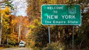
Welcome to New York sign at the Connecticut–New York state line near New Canaan, Connecticut. Photo: Miro Vrlik Photography / Shutterstock.com
New York and Connecticut share a border that looks very different depending on where you cross it. Near Long Island Sound, the state line runs through one of the busiest commuter corridors in the Northeast, with Interstate 95, the Hutchinson River Parkway, the Merritt Parkway, U.S. Route 1, and Metro-North trains moving thousands of people between Westchester County and Fairfield County every day. Farther north, the border becomes much more rural, with highways and two-lane roads connecting Putnam and Dutchess counties with Danbury, Ridgefield, Sharon, Salisbury, and the Litchfield Hills.
There is also another way to travel directly between the two states without touching the land border at all. Vehicle ferries cross Long Island Sound from Port Jefferson to Bridgeport and from Orient Point to New London, giving Long Island travelers a direct route into Connecticut without driving through New York City and Westchester County.
Travel note: Road construction, parkway vehicle restrictions, rail fares, ferry schedules, and ferry prices can change. Check 511NY, CTroads, the MTA, and the ferry operator before traveling.
Are New York–Connecticut Border Crossings Tolled?
The road crossings directly at the New York–Connecticut state line are toll-free. Connecticut does not currently collect highway tolls, and no tollbooth or toll gantry is positioned directly on the border.
However, an important exception applies to drivers using Interstate 95 on the New York side. The New England Thruway includes the New Rochelle Toll Gantry several miles southwest of the Connecticut line. The toll is collected only northbound, meaning drivers traveling from New York City and lower Westchester toward Connecticut encounter the charge before reaching the state line. Southbound drivers traveling from Connecticut toward New York City do not pay the New Rochelle toll.
As of 2026, the standard passenger-car toll at New Rochelle is $1.75 with a New York E-ZPass and $3.06 with a non-New York E-ZPass or Tolls by Mail. Drivers without E-ZPass do not stop to pay cash. The vehicle’s license plate is photographed and the bill is mailed to the registered owner. The lower E-ZPass rate applies to E-ZPassNY accounts, so drivers using a transponder issued by another state should not assume they will receive the New York discount. For more on the system, see our The Story of E-ZPass in New York and How to Sign Up.
Interstate 95 — Port Chester to Greenwich
Interstate 95 crosses the state line between Port Chester in Westchester County and Greenwich in Fairfield County. In New York, this section is part of the New England Thruway. In Connecticut, I-95 continues along the coast through Stamford, Norwalk, Bridgeport, New Haven, and eventually toward Rhode Island.
This is the principal highway crossing between the New York metropolitan area and coastal Connecticut. Passenger cars, buses, tractor-trailers, and other commercial vehicles can use the route. Traffic can become extremely heavy during weekday commuting periods, summer weekends, holidays, and major incidents anywhere along the Fairfield County corridor.
Hutchinson River Parkway to Merritt Parkway
The Hutchinson River Parkway provides another major route from Westchester County into Connecticut. At the state line near Greenwich, the roadway becomes Connecticut Route 15 and the Merritt Parkway. Unlike I-95, this is a parkway built primarily for passenger vehicles rather than commercial traffic.
Connecticut prohibits trucks, box trucks, tractor-trailers, rental moving trucks, trailers, RVs, and most other large or commercial vehicles from the Merritt Parkway. Current Connecticut Department of Transportation rules also prohibit vehicles more than 8 feet high, 24 feet long, or 7 feet 6 inches wide, subject to limited official exemptions. Drivers of vans, pickups, rental trucks, campers, or vehicles towing anything should check the restrictions before entering the parkway.
The Merritt Parkway is known for its wooded setting and historic bridge designs, but those older structures also mean low clearances. Connecticut continues to warn drivers about bridge strikes, particularly when oversized vehicles mistakenly enter the parkway.
Interstate 684 — The Highway That Briefly Enters Connecticut
Interstate 684 is one of the strangest New York–Connecticut crossings because a driver can enter Connecticut and then return to New York without taking an exit or changing highways. Northbound from Westchester County, I-684 briefly passes through the northwest corner of Greenwich for roughly 1.4 miles before crossing back into New York.
The route continues north through Westchester County toward Interstate 84 near Brewster. Because I-684 carries both passenger and commercial traffic, it is an important connection between White Plains, northern Westchester, Putnam County, and the I-84 corridor.
Interstate 84 — Brewster to Danbury
Interstate 84 crosses from the Town of Southeast in Putnam County into Danbury, Connecticut. This is the major northern interstate crossing between the two states and one of the principal routes for traffic moving between the Hudson Valley and central New England.
The crossing is toll-free in both directions and carries passenger vehicles, buses, and heavy commercial traffic. I-84 connects with I-684 and U.S. Routes 6 and 202 in the Brewster area before continuing east through Danbury toward Waterbury and Hartford. Readers interested in the New York side of this corridor can also see our Brewster, New York, A Little Village with a Big History.
U.S. Route 1 — Port Chester to Greenwich
U.S. Route 1 crosses the Byram River between Port Chester and Greenwich and provides the principal local-road alternative to I-95. Known historically as the Boston Post Road, the route passes directly through commercial districts and residential areas on both sides of the border.
Unlike the limited-access interstates and parkways, U.S. 1 has traffic signals, local intersections, businesses, pedestrians, and frequent turning traffic. It can be useful when I-95 is backed up, but it is not necessarily faster during busy periods because it serves local traffic throughout the corridor.
U.S. Route 6 — Brewster to Danbury
U.S. Route 6 crosses between Southeast, New York, and Danbury, Connecticut, near the I-84 corridor. It provides a surface-road connection between the Brewster area and western Danbury and carries a mixture of local passenger traffic and commercial vehicles.
Route 6 is toll-free and can serve as a local alternative to I-84, although it passes through developed commercial areas and has considerably more intersections than the interstate.
New York Route 35 / Connecticut Route 35 — Lewisboro to Ridgefield
New York Route 35 crosses the state line from Lewisboro in northern Westchester County into Ridgefield, where it continues as Connecticut Route 35. This is one of the most useful two-lane crossings between northern Westchester and western Connecticut.
The road carries local residents, commuters, delivery vehicles, and visitors traveling between the Cross River and South Salem area and Ridgefield. It is a much quieter crossing than I-95 or I-84 and passes through wooded residential country rather than a major commercial corridor.
New York Route 123 / Connecticut Route 123 — Lewisboro to New Canaan
New York Route 123 begins at the Connecticut state line in the Vista section of Lewisboro and continues west toward Route 35. On the Connecticut side, Route 123 continues through New Canaan and toward Norwalk.
This is another two-lane local crossing used primarily for residential and regional traffic. The original draft paired Route 123 with New York Route 172, but Route 172 does not reach Connecticut; it runs through Mount Kisco, Bedford, and Pound Ridge and ends at New York Route 137.
New York Route 343 / Connecticut Route 343 — Amenia to Sharon
New York Route 343 crosses the state line east of Amenia in Dutchess County and continues into Connecticut toward Sharon. The landscape here is very different from the heavily developed crossings farther south. The road moves through farms, open fields, wooded hills, and small communities in the Harlem Valley and Litchfield County.
This route is toll-free and is primarily used by local residents, regional travelers, agricultural traffic, and visitors exploring the rural communities on both sides of the border.
U.S. Route 44 — Millerton to Salisbury
U.S. Route 44 crosses from the Millerton area of Dutchess County into Salisbury, Connecticut. It is one of the principal northern road crossings between New York and Connecticut and continues east through the Litchfield Hills.
The crossing is toll-free and provides access between the Harlem Valley and northwestern Connecticut. It is also a useful route for travelers headed toward Lakeville, Salisbury, Lime Rock Park, and the surrounding Berkshire foothills.
Metro-North New Haven Line — New York to Connecticut by Train
For many commuters, the most important New York–Connecticut crossing is not a highway at all. Metro-North Railroad’s New Haven Line crosses the state line between Port Chester and Greenwich and continues through Stamford, Norwalk, Bridgeport, and New Haven.
The line provides frequent commuter service between Connecticut and Grand Central Terminal in Manhattan. Fares vary by origin, destination, ticket type, and peak or off-peak travel period. The same coastal rail corridor is also used by Amtrak trains, including Acela and Northeast Regional service between New York and New England.
Port Jefferson–Bridgeport Ferry
The Bridgeport & Port Jefferson Ferry provides a direct vehicle and passenger crossing between Port Jefferson on Long Island and Bridgeport, Connecticut. For Long Island residents, the ferry can eliminate the need to drive west through Queens, the Bronx, and Westchester County before turning east again into Connecticut.
The crossing takes approximately 1 hour and 15 minutes. As of September 2026, the ferry company lists a reserved one-way car-and-driver fare of $78 during off-peak periods and $80 during peak periods, with higher prices for unreserved and oversized vehicles. Reservations are recommended, especially on weekends, holidays, and during the summer.
The ferry carries passenger cars, motorcycles, buses, commercial vehicles, and walk-on passengers. Because schedules and fares change, travelers should check the ferry company directly before leaving.
Orient Point–New London Cross Sound Ferry
Cross Sound Ferry connects Orient Point at the eastern end of Long Island’s North Fork with New London, Connecticut. This crossing is especially useful for travelers from eastern Suffolk County heading toward southeastern Connecticut, Rhode Island, Cape Cod, or other parts of New England.
The standard vehicle ferry crossing takes approximately 1 hour and 20 minutes. Cross Sound Ferry also operates the passenger-only SeaJet, which makes the crossing in roughly 40 to 45 minutes on scheduled service. Vehicle reservations are not always required, but the company strongly recommends them during the busy season, and advance reservations are generally needed to receive base fares and many discounts.
Unlike the highway crossings, the Long Island Sound ferries charge fares rather than tolls. Pricing varies by vehicle type, departure, demand, reservation status, and available discounts, so travelers should check the current fare before booking.
Which New York–Connecticut Crossing Should You Use?
For travelers headed between New York City and coastal Connecticut, I-95 is the most direct highway but is often the most congested. Passenger-car drivers may prefer the Hutchinson River Parkway and Merritt Parkway when traffic conditions make that route more practical, but trucks and other prohibited vehicles must stay off the parkway. I-84 is usually the better option for travel between the Hudson Valley and Danbury or central Connecticut, while Routes 35, 123, 343, and U.S. 44 serve local and rural trips along the northern portion of the border.
For commuters between Manhattan and Fairfield County, Metro-North often provides the most predictable alternative to highway traffic. Long Island travelers have another choice entirely: the Port Jefferson–Bridgeport and Orient Point–New London ferries allow them to cross Long Island Sound directly into Connecticut without driving around the western end of the Sound.
For more New York transportation information, read our The Story of E-ZPass in New York and How to Sign Up and Brewster, New York, A Little Village with a Big History.
Sources
New York State Thruway Authority — Toll and Distance Calculator
New York State Thruway Authority — New Rochelle Toll Gantry and Toll Schedule Information
Connecticut Department of Transportation — Merritt Parkway Vehicle Restrictions
New York State Department of Transportation — New York State Touring Route Descriptions
Connecticut Department of Transportation — Route 123 and New York State Line
Metropolitan Transportation Authority — Metro-North New Haven Line Fares
Bridgeport & Port Jefferson Ferry — Schedule and Fares
Cross Sound Ferry — Travel Times, Reservations, and Passenger Information
Cross Sound Ferry — SeaJet High-Speed Passenger Service