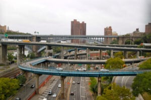
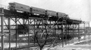
A Ninth Avenue Elevated train crossing the high curve near 110th Street in Manhattan, one of the most dramatic sections of New York City’s old elevated railway system. Photo: John S. Johnston, Public Domain, via Wikimedia Commons.
Long before the unified subway map, the Lincoln Tunnel, and today’s vast network of bridges, buses, commuter railroads, and ferries, New York moved through a remarkable patchwork of elevated trains, railroad terminals, trolley systems, ferryboats, and even railcars that crossed the harbor on barges.
Many of those systems disappeared as newer subways, highways, tunnels, and modern terminals took their place. Yet traces of them remain throughout the city: in street patterns, surviving infrastructure, public parks, active transit hubs, and the routes New Yorkers still travel every day. These 10 lost transit lines, terminals, and ferry systems helped build the New York we know today.
1. The Ninth Avenue Elevated
Experimental Beginnings: 1867–1868
Passenger Service: 1870–1940 in Manhattan
Route: Lower Manhattan north along Greenwich Street and Ninth Avenue, later extending to 155th Street with connections toward the Bronx
Charles T. Harvey’s experimental elevated railway rose above Greenwich Street in the late 1860s. By 1870, passenger service had begun on what the Museum of the City of New York describes as the world’s first elevated street railroad. The original cable-powered system proved unreliable and was soon replaced by steam locomotives. The line was later electrified and became part of the vast Manhattan elevated network.
One of its most spectacular sections was the high reverse curve between the 104th Street and 116th Street stations. Contemporary film preserved by the Library of Congress shows trains sweeping around what became known as the “Big Curve,” where the tracks rose more than 100 feet above the surrounding streets near northern Central Park and Morningside Heights.
What Happened: The city-owned IND Eighth Avenue subway opened in 1932 and duplicated much of the West Side elevated’s function. The Manhattan portion of the Ninth Avenue El closed on June 12, 1940. A remnant north of 155th Street survived as the Polo Grounds Shuttle until 1958.
2. The Third Avenue Elevated
Manhattan Era: 1878–1955
Route: Lower Manhattan north through the Bowery and Third Avenue to Harlem, with service continuing into the Bronx
The Third Avenue El became one of the defining transportation lines of Manhattan’s East Side. Steam-powered trains originally ran above streets lined with shops, saloons, tenements, and businesses before the system was electrified. Its iron structure cast deep shadows over the Bowery and Third Avenue and became an unmistakable part of old New York’s visual landscape.
The line survived longer in Manhattan than the Second, Sixth, and Ninth Avenue elevateds. It became a favorite subject for photographers and filmmakers and appeared in movies including The Lost Weekend and The Naked City.
What Happened: Manhattan service ended on May 12, 1955. Removing the structure opened Third Avenue to sunlight and accelerated redevelopment along the corridor. The Bronx section survived for another 18 years, finally closing in 1973.
3. The Sixth Avenue Elevated
Active Years: 1878–1938
Route: Lower Manhattan north along Sixth Avenue to Central Park South
The Sixth Avenue El carried workers, shoppers, theatergoers, and residents through one of Manhattan’s most important commercial corridors. Its trains passed through the Ladies’ Mile shopping district and later through Herald Square and Midtown, serving a rapidly developing stretch of Manhattan.
By the 1930s, merchants and property owners increasingly viewed the elevated structure as noisy, dark, and harmful to property values. The city purchased the line for $12.5 million in 1938 as construction of the underground IND Sixth Avenue subway moved forward.
What Happened: The final trains ran on December 4, 1938, and demolition followed. A famous later story claimed that the steel from the Sixth Avenue El was sold to Japan and returned to the United States in the form of wartime weapons. Contemporary investigations found that story to be false: virtually all of the salvaged iron and steel went to American companies for remelting.
4. Grand Central Depot and Grand Central Station
Predecessor Era: 1871–1910s
Location: 42nd Street and Park Avenue
Before today’s Grand Central Terminal opened in 1913, two earlier railroad complexes occupied the site. Cornelius Vanderbilt’s Grand Central Depot opened in 1871, bringing the New York Central & Hudson River Railroad, New York & Harlem Railroad, and New York & New Haven Railroad together beneath a huge train shed.
The complex was extensively rebuilt and expanded in the late 1890s and became known as Grand Central Station. Yet steam locomotives still approached through the Park Avenue tunnel and open-cut tracks, creating smoke, noise, and dangerous visibility conditions.
A deadly 1902 collision in the smoke-filled Park Avenue tunnel killed 15 people. New York State subsequently required the elimination of steam-powered passenger operations on the Park Avenue tracks south of the Harlem River. Electrification made it possible to bury the tracks, create a two-level terminal, and develop valuable real estate above the railroad.
What Happened: The old station and train shed were dismantled in stages as the present Grand Central Terminal was constructed. The new terminal opened in 1913. For the full story of the building that replaced them, read Grand Central Terminal, A Postmodern Cathedral.
5. The Brooklyn Bridge Railway and Trolley Terminals
Transit Era: 1883–1950
Locations: Park Row in Manhattan and Sands Street in Brooklyn
When the Brooklyn Bridge opened in 1883, mass transit was built directly into its design. A cable-powered railway carried passengers between terminals at the Manhattan and Brooklyn ends of the bridge. The trains were pulled by a continuously moving cable powered from the Brooklyn side.
As Brooklyn’s streetcar and elevated networks expanded, the bridge became an even more important transit funnel. In 1898, electric trolley lines began operating directly across the bridge to Park Row. In the early 20th century, the old cable railway gave way to electric operation and through elevated-train service, while local trolley cars continued to carry enormous numbers of riders between the boroughs.
What Happened: Elevated-train service across the bridge ended in 1944. The bridge’s last trolley made its final run on March 6, 1950, as the structure was rebuilt to accommodate more automobile traffic. The old transit tracks and much of the terminal infrastructure disappeared as the approaches were modernized.
6. The West Shore Railroad Ferries at Weehawken
Ferry Era: 1884–1959
Route: Weehawken Terminal in New Jersey to West 42nd Street and Cortlandt Street in Manhattan
Before the Hudson River highway tunnels transformed travel between Manhattan and New Jersey, the West Shore Railroad depended on ferries to complete the trip into New York City. Passengers arriving at Weehawken by train transferred to large ferryboats for the final crossing to Manhattan.
The West Shore route served commuters as well as passengers traveling from communities along the Hudson River and points farther north. At Weehawken, railroad tracks, ferry slips, freight yards, car floats, trolleys, and local transportation came together in one enormous waterfront complex.
What Happened: Competition from automobiles, buses, the George Washington Bridge, and the Lincoln Tunnel steadily reduced ridership. The West Shore ferries were discontinued in March 1959. Passenger trains continued for several more months without the old ferry connection, with the final West Shore passenger service ending on December 10, 1959.
What’s There Today: Passenger ferry service returned to the Weehawken waterfront in the 1980s. The modern Port Imperial area is once again a major ferry and transit connection across the Hudson.
7. The Long Island Rail Road Car Float Gantries
Freight Float Era: Late 19th century–1970s
Location: Long Island City waterfront, Queens
Long before trucks dominated regional freight, railroad boxcars themselves crossed New York Harbor by boat. At Long Island City, the Long Island Rail Road rolled freight cars onto car floats, barges fitted with railroad tracks. Tugboats then moved the floating railcars between Long Island and other railroad freight terminals around New York Harbor.
Because the height of a floating barge changed with the tide, massive movable gantries helped align the railroad tracks on land with the tracks on the car floats. The surviving Long Island City gantries were rebuilt for the LIRR in 1925 and remained associated with freight operations into the 1970s.
What Happened: Trucking, changing freight patterns, and the decline of traditional waterfront railroad operations made the Long Island City car-float system obsolete.
What’s There Today: The restored gantries are the industrial centerpiece of Gantry Plaza State Park. New York State Parks describes them as monuments to the waterfront’s rail-freight past.
8. The Original City Hall Subway Station
Active Years: 1904–1945
Location: Beneath City Hall Park, Lower Manhattan
City Hall was the ceremonial showpiece of New York’s first subway. The original Interborough Rapid Transit line opened on October 27, 1904, and the first subway ride departed from City Hall amid enormous civic celebration.
Architects Heins & LaFarge created a station unlike almost any that followed. Its curved platform sits beneath elegant Guastavino tile vaults, brass chandeliers, and leaded-glass skylights. The station’s sweeping design reflected the City Beautiful movement and was intended to announce that the new subway was not merely infrastructure but a civic achievement.
What Happened: City Hall’s tight curve and short platform became increasingly impractical as subway trains grew longer, while the nearby Brooklyn Bridge station handled far more passengers. City Hall was decommissioned in 1945.
What’s There Today: The track remains active as the turnaround loop for the downtown 6 train, but trains do not stop at the station. The New York Transit Museum offers tightly controlled members-only tours of the historic platform. For more on the surviving stations from the original system, see 10 Oldest Subway Stations in NYC Still Operating.
9. Hudson Terminal and the Hudson & Manhattan Railroad
Terminal Service: 1909–1971
Location: Church Street between Cortlandt and Fulton Streets, Lower Manhattan
Before PATH trains arrived at the World Trade Center, the Hudson & Manhattan Railroad brought New Jersey passengers into Hudson Terminal. Downtown service through the Hudson Tubes began on July 19, 1909.
Hudson Terminal was one of the earliest great examples of transit-oriented development. Below ground, train platforms connected Manhattan with Jersey City and the growing H&M network. Above the terminal rose two 19-story Renaissance Revival office towers designed by Clinton & Russell. Federal documentation describes Hudson Terminal as the first major railroad terminal to combine a substantial office complex directly with rail transportation.
What Happened: The Hudson & Manhattan Railroad entered bankruptcy, and the Port Authority acquired the system in 1962, creating PATH. Hudson Terminal remained in use until 1971 as construction of the original World Trade Center transformed the site.
What’s There Today: PATH service continues at the World Trade Center, now centered on the modern Oculus Transportation Hub.
10. The Putnam Division, “The Old Put”
Passenger Era: 1880–1958
Route: The Bronx through Westchester County to Brewster in Putnam County
Affectionately remembered as “The Old Put,” the Putnam line linked the Bronx with suburban and rural communities through Westchester and Putnam counties. The route passed through Van Cortlandt Park and continued north through communities including Yonkers, Ardsley, Elmsford, Yorktown Heights, and Brewster.
By the 20th century, the Putnam Division faced serious disadvantages compared with the New York Central’s Hudson and Harlem divisions. It lacked direct service to Grand Central Terminal, widespread commuter parking, electrification, and the capacity of the larger parallel routes. The growing highway network also gave suburban commuters new alternatives.
What Happened: The final passenger trains ran on May 29, 1958. Freight service continued on portions of the former line for years afterward, with individual segments surviving into the early 1980s.
What’s There Today: Much of the former railbed has become a recreational trail. In the Bronx, the Old Putnam Trail runs through Van Cortlandt Park, while the South County and North County Trailways continue north through Westchester along large portions of the former railroad corridor.
More New York Transit History
New York’s modern transportation system still follows routes and connections established by earlier generations of railroads, bridges, terminals, and subways. For more, read our Grand Central Terminal, A Postmodern Cathedral, History of the Brooklyn Bridge, 10 Oldest Subway Stations in NYC Still Operating, and History of New York’s Oculus Transportation Hub at the WTC.
Sources
Museum of the City of New York: Charles T. Harvey and New York’s First Elevated Street Railroad
New York Transit Museum: The Manhattan Elevateds
New York Transit Museum: The IRT Third Avenue Elevated
The New Yorker: The Sixth Avenue El Scrap-Steel Myth
New York City Department of City Planning: Grand Central Subdistrict History
Brooklyn Museum: Brooklyn Bridge Chronology
U.S. District Court: Hudson River Railroad Ferry Closures in 1959
New York Central System Historical Society: Marine Operations and the West Shore Ferries
New York City Environmental Review: Long Island Rail Road Car Float Gantries
New York State Parks: Gantry Plaza State Park
New York Transit Museum: Old City Hall Station
Port Authority of New York and New Jersey: Before PATH Became PATH
Library of Congress HABS: World Trade Center Site and Hudson Terminal History
New York Central System Historical Society: Putnam Division History
Updated August 23, 2026.