The Greatest Transit System on Earth, Built by Hand
Ask any real New Yorker how they get around this city, and the answer is almost never a car. It is the subway, and it has been the subway for more than 120 years. Before there was Google Maps, before there was a Citi Bike dock on every corner, there was a hole in the ground beneath Manhattan, and everything about how this city moved changed forever.
I have ridden these trains my whole life, and I will say something that might sound strange coming from a history teacher rather than a transit engineer. The New York City subway is not just infrastructure. It is the circulatory system of the greatest city on earth, and it is one of the only truly democratic spaces left in America. A hedge fund manager and a dishwasher stand on the same platform, wait for the same delayed train, and squeeze into the same crowded car during rush hour. Nowhere else in this country does that happen the way it happens here, every single day, underground.
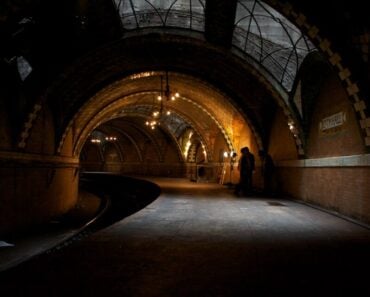
On October 27, 1904, Mayor George B. McClellan Jr. took the controls of the ceremonial first train at the ornate, curved City Hall station. By the end of opening day, more than 100,000 New Yorkers had paid a nickel each for the privilege of descending into a brand-new underground world. The original 9.1-mile line ran north from City Hall beneath Park Avenue South, cut west across 42nd Street, and turned north up Broadway to 145th Street in Harlem. New York had never seen anything like it.
I want to address something directly because I hear it constantly from visitors and even from some of my own students. People are scared to ride the subway. I understand where that fear comes from, and I am not going to pretend the system is flawless or that nothing bad has ever happened underground. But the scale matters. The subway carried more than 1.28 billion riders in 2025, with average weekday ridership slightly above four million. Major crime during that year stood at roughly 1.65 incidents per million rides, its lowest rate in 16 years. A frightening incident makes headlines. Millions of safe, ordinary rides do not.
What has genuinely changed, and changed for the better, is how the system feels to use. Countdown clocks tell riders when trains are approaching. Apps place real-time service changes in the palm of your hand. OMNY allows passengers to tap a contactless bank card, phone, wearable device, or OMNY card at the turnstile. The MTA has also installed low platform-edge barriers at more than 100 stations, improved lighting, and expanded outreach and enforcement efforts throughout the system. It is a smarter and more modern subway than the one I grew up riding, even as its oldest structures continue carrying New Yorkers every day.
Underneath all that modernization, something remarkable has survived. Many stations from the original 1904 line remain in operation, carrying commuters past tiled walls, terra-cotta plaques, and mosaic tablets installed by hand more than a century ago. The ten stations below all opened on October 27, 1904, so the numbering follows the original route and the stories behind each stop rather than an age ranking.
The Mastermind Architects: Heins and LaFarge
Before you step onto the platform at any of these stations, look closely at the walls. Chief Engineer William Barclay Parsons insisted that the subway should not feel like a dark, gloomy tunnel. The city hired the architectural firm of George L. Heins and Christopher Grant LaFarge, which was also involved with the Cathedral of St. John the Divine, to develop the decorative character of the original stations. Their designs used terra cotta, ceramic tile, mosaics, marble, Roman brick, and symbolic plaques to transform underground transit into a civic environment rather than a purely functional one.
Heins and LaFarge treated each station like a small public monument. Individual colors, images, name tablets, and neighborhood symbols helped riders distinguish one stop from another. That decision is why these century-old walls still have so much to say.
| October 27, 1904: Opening-Day Facts | |
|---|---|
| Fare | 5 cents; the subway token was introduced in 1953 |
| Initial Operating Line | City Hall to 145th Street and Broadway |
| Original Operator | Interborough Rapid Transit Company, known as the IRT |
| Stations Opened | 28 |
| Route Length | 9.1 miles |
| Station Architects | Heins and LaFarge, working with Chief Engineer William Barclay Parsons |
1. Brooklyn Bridge–City Hall
Opened: October 27, 1904
Lines Served: 4, 5, and 6 trains
Key Historic Feature: Original IRT express station beside the closed City Hall loop
Brooklyn Bridge–City Hall opened as the downtown express station beside the original City Hall terminal. The active station has been enlarged, rebuilt, and adapted repeatedly, but it still occupies one of the most historically important locations in the entire system. Just beyond its downtown platforms sits the abandoned City Hall station, the architectural showpiece where New York’s first ceremonial subway ride began.
The famous Guastavino tile vaults, chandeliers, leaded skylights, and sweeping curved platform belong to that closed City Hall loop station, not to the active Brooklyn Bridge platforms. City Hall closed to regular passenger service in 1945, but downtown 6 trains still travel through the loop to reverse direction and return uptown. That makes Brooklyn Bridge–City Hall the working gateway to the subway’s most celebrated ghost station.
2. Astor Place
Opened: October 27, 1904
Lines Served: 6 train
Key Historic Feature: Terra-cotta beaver plaques honoring John Jacob Astor
Astor Place remains one of the most artistically distinctive original stations on the Lexington Avenue local line. The station takes its name from John Jacob Astor, the fur trader and real estate baron who became one of America’s wealthiest men. Heins and LaFarge marked the connection with glazed ceramic wall plaques depicting beavers, the animal whose pelts helped build Astor’s early fortune.
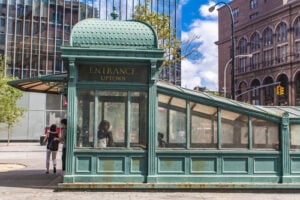
Portions of the station’s original interior were designated a New York City landmark in 1979. A replica of an early IRT entrance kiosk also stands aboveground at Astor Place and Lafayette Street. Step outside after your ride and you are close to Cooper Union, where Abraham Lincoln delivered his famous 1860 address months before winning the presidency.
3. Bleecker Street–Broadway-Lafayette Street
Opened: October 27, 1904
Lines Served: 6 train, with transfers to the B, D, F, and M trains
Key Historic Feature: Original blue-and-white B mosaic tablets with tulip motifs
Constructed beneath Lafayette Street, Bleecker Street still displays original decorative work from the first IRT. Its blue-and-white mosaic tablets feature a central letter B framed by stylized tulips and ornamental borders, giving the station an identity that remains recognizable more than a century later.
The station’s platforms were originally built for much shorter local trains. Riders who look closely can distinguish sections of the original station from later platform extensions and renovation work. The long-awaited connection between the uptown 6 platform and Broadway-Lafayette Street opened in 2012, finally creating a complete transfer between the IRT station and the B, D, F, and M lines.
4. 14th Street–Union Square
Opened: October 27, 1904
Lines Served: 4, 5, 6, L, N, Q, R, and W trains
Key Historic Feature: Mechanical platform gap fillers on the curved Lexington Avenue express platforms
Union Square has served as a major transit junction since its first day in operation. The original IRT platforms were built on a sharp curve, creating a wide space between the train doors and the platform edge. The solution was a set of movable mechanical gap fillers that extend when a train arrives and retract before it departs, one of the system’s most unusual pieces of working station equipment.
Fragments of the original decorative scheme remain visible throughout the complex, including eagle-and-shield motifs connected with Union Square’s civic identity. The station’s history also mirrors the public square above, which has hosted labor rallies, political speeches, memorial gatherings, celebrations, and protests for generations.
5. Grand Central–42nd Street
Opened: October 27, 1904
Lines Served: 4, 5, 6, 7, and S trains
Key Historic Feature: The original 1904 east-west trackway now used by the 42nd Street Shuttle
When Grand Central opened on the subway’s first day, the original route did not continue straight north along Lexington Avenue. Instead, it turned west across 42nd Street toward Times Square before heading north beneath Broadway. The surviving east-west portion of that original route is now the 42nd Street Shuttle.
The Lexington Avenue Line platforms used by the 4, 5, and 6 trains opened later, during the system’s major 1918 expansion, and the 7 train arrived as part of another line. The shuttle is the direct physical survivor of the 1904 route. Ride it with that history in mind, and the short trip between Grand Central and Times Square becomes a journey across one of the oldest continuously used pieces of subway infrastructure in New York.
6. Times Square–42nd Street
Opened: October 27, 1904
Lines Served: 1, 2, 3, 7, N, Q, R, W, and S trains, with an underground passage to the A, C, and E trains
Key Historic Feature: The original 1904 station survives within the current shuttle area
Long before Times Square became a glowing forest of digital billboards, the intersection was known as Longacre Square. It was renamed Times Square in 1904 after The New York Times moved into its new headquarters at One Times Square, months before the subway opened beneath the intersection.
The station complex riders know today developed in stages. The original 1904 portion is associated with the present shuttle, while the Broadway and Seventh Avenue subway platforms opened later. Times Square–42nd Street remains the busiest station complex in the system, handling more than 61 million entries during 2025. Beneath the billboards and crowds, part of the city’s first subway route is still doing the same essential work it began more than a century ago.
7. 59th Street–Columbus Circle
Opened: October 27, 1904
Lines Served: 1, A, B, C, and D trains
Key Historic Feature: Ceramic plaques depicting Christopher Columbus’s ship, the Santa Maria
Marking the southwest entrance to Central Park, the original Columbus Circle station opened on the Broadway branch of the IRT. To connect the station with the traffic circle above, Heins and LaFarge created faience plaques depicting a caravel sailing across blue waves, traditionally identified as Columbus’s flagship, the Santa Maria.
The complex has been expanded substantially to connect the 1 train with the A, B, C, and D lines. Yet portions of the original decorative work remain, leaving a small maritime scene embedded in the walls beneath one of Manhattan’s busiest intersections.
8. 72nd Street
Opened: October 27, 1904
Lines Served: 1, 2, and 3 trains
Key Historic Feature: Original Flemish Renaissance control house on the Broadway median
While many subway entrances lead directly down from a sidewalk staircase, 72nd Street preserves one of the original control houses built for the first IRT. The brick, stone, and terra-cotta structure stands in the Broadway median and once contained ticket booths, entry gates, and the main circulation space for passengers descending to the platforms.
Heins and LaFarge designed the building in the Flemish Renaissance style, with a steep roofline, ornamental gables, and decorative details that gave the practical entrance building the dignity of civic architecture. A second entrance building was added decades later, but the original 1904 control house remains one of the most recognizable surviving structures from the first subway.
9. 116th Street–Columbia University
Opened: October 27, 1904
Lines Served: 1 train
Key Historic Feature: Blue-and-white Columbia University seal plaques
This station was designed to serve Columbia University’s Morningside Heights campus, which had moved uptown from Midtown in 1897. Its decorative program connected the station directly with the institution above through blue-and-white plaques bearing the university’s name and seal.
The station’s original mosaic tablets, glazed tile, terra-cotta ornament, and tiled columns were among the portions designated as an interior landmark. Generations of students, professors, workers, and neighborhood residents have passed those same decorations on their way beneath Broadway.
10. 145th Street and Broadway
Opened: October 27, 1904
Lines Served: 1 train
Key Historic Feature: Original northern terminal of the opening-day subway
When the IRT opened on October 27, 1904, 145th Street and Broadway marked the northern end of the operating line. A passenger who wanted to travel farther into Washington Heights or the Bronx had to use surface transportation until subway extensions opened during the years that followed.
The station’s platforms were later lengthened and the line continued north, but its place in subway history remains fixed. In 1904, this was the frontier stop at the far end of New York’s brand-new underground railroad, the place where the first chapter of the subway map came to an end.
Quick Reference: Original 1904 IRT Station Highlights
| Station | Original Portion | Historic Detail |
|---|---|---|
| Brooklyn Bridge–City Hall | Lexington Avenue express station | Gateway to the closed City Hall loop |
| Astor Place | Lexington Avenue local station | Terra-cotta beaver plaques |
| Bleecker Street | Lexington Avenue local station | Blue B tablets with tulip motifs |
| 14th Street–Union Square | Lexington Avenue platforms | Mechanical platform gap fillers |
| Grand Central–42nd Street | Current shuttle route | Original east-west IRT trackway |
| Times Square–42nd Street | Current shuttle area | Original station on the 1904 route |
| 59th Street–Columbus Circle | Broadway local station | Santa Maria ship plaques |
| 72nd Street | Broadway express station | Flemish Renaissance control house |
| 116th Street–Columbia University | Broadway local station | Columbia University plaques |
| 145th Street | Broadway terminal station | Opening-day northern terminus |
Classic NYC Transit Tip
The most complete way to see the abandoned City Hall station is through an official New York Transit Museum tour. The station is a restricted site, and guided access is offered to museum members through scheduled programs. Downtown 6 trains continue through the loop after Brooklyn Bridge–City Hall, and riders may sometimes catch a brief glimpse from inside the train, but passengers should always follow crew instructions and never enter restricted areas.
More New York Transit History
Readers interested in the history beneath New York’s streets can also explore our stories on Union Square Station, Grand Central Terminal, Times Square, the 168th Street subway station, and the long history of the Second Avenue Subway project.
10 Original 1904 NYC Subway Stations Still in Service article published on ClassicNewYorkHistory.com © 2026