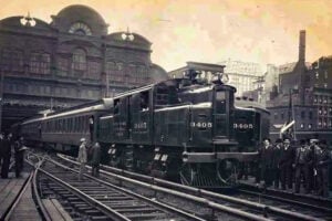
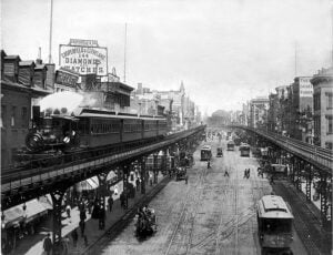
A steam train travels along the Third Avenue Elevated above the Bowery in New York City in 1896. Public domain, via Wikimedia Commons.
New York City’s transit map is filled with ghosts. Elevated trains once rattled above Manhattan and Brooklyn, short shuttles connected neighborhoods and stadiums, Staten Island had passenger branches that vanished in the 1950s, and Long Island Rail Road trains once used a Queens corridor that has been silent for more than six decades.
Some of these lines disappeared because newer underground subways made them redundant. Others fell victim to declining ridership, competition from buses and automobiles, municipal transit policy, changing development patterns, or the fiscal problems of the 1970s. This first installment in our Lost Railways of New York series looks at 15 vanished subway, elevated, and railroad lines within the five boroughs and what, if anything, remains of them today.
1. The Ninth Avenue Elevated
Boroughs Served: Manhattan and The Bronx
Original Route: The mature line ran from Lower Manhattan north along Greenwich Street, Ninth Avenue, and Columbus Avenue to 155th Street, with later service continuing into The Bronx.
Years of Operation: Experimental elevated operation began in 1868; regular passenger service began in 1870. The Manhattan main line closed in 1940.
Operating Companies: West Side and Yonkers Patent Railway; New York Elevated Railroad; Manhattan Railway Company; Interborough Rapid Transit Company.
Why It Vanished: Charles T. Harvey’s experimental railway on Greenwich Street became the world’s first elevated street railroad carrying regular passengers. It began with cable power, later switched to steam, and was eventually electrified. By the 1930s, however, the city-built IND Eighth Avenue subway provided a modern underground alternative on Manhattan’s West Side. Following municipal transit unification in 1940, the Ninth Avenue El south of 155th Street closed on June 11, 1940.
What Remains Today: The Manhattan elevated structure is gone. The most substantial surviving remnants are associated with the former Polo Grounds connection farther north, including portions of the tunnel and station infrastructure described later in this article.
2. The Sixth Avenue Elevated
Borough Served: Manhattan
Original Route: Lower Manhattan north along Church Street and West Broadway before running above Sixth Avenue toward Midtown, where it connected with the Ninth Avenue system.
Years of Operation: 1878-1938
Operating Companies: Gilbert Elevated Railway; Metropolitan Elevated Railway; Manhattan Railway Company; Interborough Rapid Transit Company.
Why It Vanished: The Sixth Avenue El was famous for its ornate passenger stations designed by Hudson River School painter and trained architect Jasper Francis Cropsey. Like Manhattan’s other elevated lines, however, it was increasingly criticized for noise, shadows, street obstruction, and an aging structure. Construction of the IND Sixth Avenue subway created a modern underground replacement. The El made its final run on December 4, 1938, and demolition followed.
What Remains Today: The old elevated structure is gone. The IND Sixth Avenue Line opened beneath the corridor in 1940, and the avenue later developed into the modern commercial corridor known as Avenue of the Americas.
3. The Second Avenue Elevated
Boroughs Served: Manhattan and The Bronx
Original Route: From Lower Manhattan north along Division Street, Allen Street, First Avenue, and Second Avenue to East Harlem, with service eventually continuing into The Bronx.
Years of Operation: 1880-1942
Operating Companies: Metropolitan Elevated Railway; Manhattan Railway Company; Interborough Rapid Transit Company.
Why It Vanished: The Second Avenue El once formed one of the East Side’s principal rapid-transit corridors. Service north of 60th Street ended in 1940, and the remaining Manhattan section closed on June 13, 1942. The city had long envisioned an underground replacement, but the Second Avenue Subway became one of the longest-delayed transportation projects in New York history.
What Remains Today: No major portion of the elevated structure survives. Phase 1 of the modern Second Avenue Subway finally opened on January 1, 2017, 75 years after the last section of the old El closed.
4. The Third Avenue Elevated and the Bronx 8 Train
Boroughs Served: Manhattan and The Bronx
Original Route: From Lower Manhattan north along the Bowery and Third Avenue, crossing the Harlem River and continuing through The Bronx toward Fordham Road and Gun Hill Road.
Years of Operation: 1878-1955 in Manhattan; service continued in The Bronx until 1973.
Operating Companies: New York Elevated Railroad; Manhattan Railway Company; Interborough Rapid Transit Company; New York City Transit Authority.
Why It Vanished: The Third Avenue El outlived Manhattan’s other major elevated lines, but sections were gradually eliminated after World War II. The remaining Manhattan service from Chatham Square to East 149th Street ended on May 12, 1955. The Bronx portion survived for another 18 years. Beginning in 1967, that service was officially designated the 8 train on maps and signs, although the cars themselves generally displayed shuttle markings. The Bronx El made its final runs on April 28, 1973.
What Remains Today: The elevated structure was demolished. The avenue alignments remain, but the old Third Avenue rapid-transit corridor in The Bronx was never rebuilt as another rail line.
5. The Polo Grounds Shuttle
Boroughs Served: Manhattan and The Bronx
Original Route: From 155th Street in Upper Manhattan across the Harlem River on the Putnam Bridge, through the Sedgwick Avenue-Anderson Avenue tunnel, and into the Jerome Avenue elevated line in The Bronx.
Years of Operation: 1918-1958; operated as a separate shuttle after the Ninth Avenue El closed in 1940.
Operating Companies: Interborough Rapid Transit Company; New York City Transit Authority.
Why It Vanished: The line survived the 1940 demolition of the Ninth Avenue El because it still served riders traveling between Upper Manhattan, The Bronx, the Polo Grounds, and connections to the Jerome Avenue Line. Ridership declined sharply after the New York Giants left the Polo Grounds for San Francisco following the 1957 baseball season and after passenger service on the New York Central’s Putnam Division ended. The shuttle closed on August 31, 1958.
What Remains Today: The Putnam Bridge was removed, but ruins of the Sedgwick Avenue and Anderson-Jerome stations and portions of the tunnel between them still survive behind restricted access.
6. The Fulton Street Elevated
Boroughs Served: Brooklyn and Queens, with former through service to Manhattan
Original Route: From Fulton Ferry and, through connecting elevated routes, Park Row in Manhattan, east across Brooklyn along Fulton Street and eventually along Liberty Avenue into Queens.
Years of Operation: 1888-1940 for the western section; portions continued until 1956.
Operating Companies: Kings County Elevated Railway; Brooklyn Rapid Transit Company; Brooklyn-Manhattan Transit Corporation; New York City Transit Authority.
Why It Vanished: The city-built IND Fulton Street subway opened beneath the corridor beginning in 1936, making much of the older elevated route redundant. Service west of Rockaway Avenue ended on May 31, 1940. The remaining middle section survived until April 1956, when the IND subway was connected directly to the eastern elevated structure.
What Remains Today: The easternmost elevated portion survived and became part of the modern A train route along Liberty Avenue to Ozone Park-Lefferts Boulevard. In other words, a piece of this 19th-century elevated railroad is still carrying subway passengers today, although the structure has been modified and rebuilt over the years.
7. The Brooklyn Lexington Avenue Elevated
Borough Served: Brooklyn
Original Route: The original line opened between York and Washington Streets and Gates Avenue, later becoming part of a larger elevated network extending through central Brooklyn and East New York.
Years of Operation: 1885-1950 for the surviving Lexington Avenue section.
Operating Companies: Brooklyn Elevated Railroad; Brooklyn Rapid Transit Company; Brooklyn-Manhattan Transit Corporation; City of New York.
Why It Vanished: Opened in May 1885, the Lexington Avenue Elevated was the first standard elevated railway in Brooklyn. As newer subway routes expanded and older elevated structures lost riders, the Lexington Avenue portion became increasingly difficult to justify. The last service over the surviving western section ended in October 1950.
What Remains Today: The Lexington Avenue portion itself is gone, but parts of the elevated network with which it connected survive farther east as components of today’s BMT Jamaica Line used by the J and Z trains.
8. The Brooklyn Fifth Avenue and Third Avenue Elevated
Borough Served: Brooklyn
Original Route: From Downtown Brooklyn south over Fifth Avenue, then along 38th Street and Third Avenue to 65th Street in Bay Ridge.
Years of Operation: 1888-1940, with the Third Avenue extension completed in 1893.
Operating Companies: Brooklyn Elevated Railroad; Brooklyn Rapid Transit Company; Brooklyn-Manhattan Transit Corporation.
Why It Vanished: The elevated line served Park Slope, Sunset Park, and Bay Ridge, but the BMT Fourth Avenue subway opened a faster underground route through the same general corridor. Service ended at municipal transit unification on June 1, 1940, and demolition followed in 1941.
What Remains Today: The original elevated railroad is gone. Portions of the old Third Avenue corridor were subsequently used in the construction of the elevated highway approach that became part of the Gowanus Expressway.
9. The Western Myrtle Avenue Elevated
Boroughs Served: Brooklyn and, through earlier service, Manhattan
Original Route: The line once ran from Park Row in Manhattan across the Brooklyn Bridge and through Downtown Brooklyn before continuing east along Myrtle Avenue toward Middle Village, Queens.
Years of Operation: 1889-1969 for the western section discussed here.
Operating Companies: Brooklyn Elevated Railroad; Brooklyn Rapid Transit Company; Brooklyn-Manhattan Transit Corporation; New York City Transit Authority.
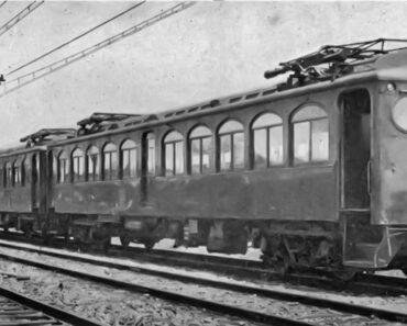
Why It Vanished: Rail service across the Brooklyn Bridge ended in 1944, leaving the route cut back to Bridge-Jay Streets. The aging western elevated structure survived another quarter century. Its last trains ran on October 4, 1969, ending an era that included some of the last wooden elevated cars in regular rapid-transit service.
What Remains Today: The western Downtown Brooklyn portion was demolished, but the eastern section from Broadway toward Middle Village remains in operation as part of today’s M train route.
10. The BMT Culver Shuttle
Borough Served: Brooklyn
Original Route: Ninth Avenue station’s lower level in Sunset Park to Ditmas Avenue in Kensington, with intermediate stops at Fort Hamilton Parkway and 13th Avenue.
Years of Operation: Shuttle service began in 1954 and became an isolated full-time shuttle in 1959; service ended in 1975.
Operating Companies: Brooklyn-Manhattan Transit Corporation; New York City Transit Authority.
Why It Vanished: The Culver route had much older railroad roots, but the shuttle was created after the city connected the southern Culver elevated line to the IND subway at Ditmas Avenue in 1954. Through BMT service continued for several years before the remaining connection was reduced to the Ninth Avenue-Ditmas Avenue shuttle in 1959. By the 1970s, ridership was extremely low and the deteriorating structure needed expensive repairs. The shuttle made its final run on May 11, 1975.
What Remains Today: The elevated structure between Ninth Avenue and Ditmas Avenue was demolished during the 1980s. The abandoned lower level at Ninth Avenue station remains, along with limited track and structural remnants associated with the former route.
11. Staten Island Railway North Shore Branch
Borough Served: Staten Island
Original Route: St. George Terminal west along the Kill Van Kull through New Brighton, West Brighton, Port Richmond, Mariners Harbor, Arlington, and Port Ivory.
Years of Passenger Operation: 1886-1953
Operating Company: Staten Island Rapid Transit, historically controlled by the Baltimore & Ohio Railroad.
Why It Vanished: The North Shore Branch was electrified in 1925, and later grade-crossing elimination projects modernized portions of the system. After New York City took control of most Staten Island bus routes and reduced fares, rail ridership fell sharply. Passenger service on both the North Shore and South Beach branches ended at midnight on March 31, 1953.
What Remains Today: The eastern passenger route remains abandoned, with sections of track, bridges, platforms, and right-of-way still visible. Freight service eventually returned to the western end of the North Shore corridor, and a short eastern section briefly carried passenger trains to the Staten Island Yankees’ ballpark during the 2000s.
12. Staten Island Railway South Beach Branch
Borough Served: Staten Island
Original Route: From the Main Line near Clifton south along Staten Island’s East Shore through Rosebank, Fort Wadsworth, Arrochar, South Beach, and Wentworth Avenue.
Years of Operation: 1888-1953
Operating Company: Staten Island Rapid Transit.
Why It Vanished: The branch once carried riders toward Staten Island’s popular East Shore beaches and resort districts. Like the North Shore Branch, it lost riders as city buses became cheaper and more convenient. Passenger service ended on March 31, 1953, and the line was abandoned soon afterward.
What Remains Today: Most of the railway was removed, but scattered traces of the former right-of-way and a few structural remnants survive. The branch remains an important part of the transportation history of neighborhoods such as Arrochar and South Beach.
13. The Long Island Rail Road Rockaway Beach Branch
Borough Served: Queens
Original Route: From Whitepot Junction in Rego Park south through Forest Hills, Glendale, Woodhaven, and Ozone Park, continuing across Jamaica Bay toward the Rockaways.
Years of Operation: The line dates to 1880; LIRR passenger service on the remaining northern segment ended in 1962.
Operating Companies: New York, Woodhaven and Rockaway Railroad; Long Island Rail Road.
Why It Vanished: A major fire in 1950 damaged the wooden Jamaica Bay trestle, after which LIRR service was cut back. The railroad sold the portion south of Ozone Park to New York City in 1952. The city rebuilt the bay crossing and incorporated it into the subway system, with A train service to the Rockaways beginning in 1956. The LIRR continued serving Ozone Park on the isolated northern portion until declining ridership led to its abandonment in 1962.
What Remains Today: Roughly 3.5 miles of the former northern right-of-way remain through central Queens. The corridor has become the focus of competing proposals for a linear park known as QueensWay and renewed rail transit promoted as QueensLink.
14. The Third Avenue El’s 34th and 42nd Street Branches
Borough Served: Manhattan
Original Routes: The 34th Street branch ran east from the Third Avenue El toward the East 34th Street ferry terminal. The 42nd Street branch ran west from Third Avenue toward Grand Central.
Years of Operation: 1878-1930 for the 34th Street branch; 1878-1923 for the Grand Central branch.
Operating Companies: New York Elevated Railroad; Manhattan Railway Company; Interborough Rapid Transit Company.
Why They Vanished: These short elevated branches belonged to an era when ferry terminals and railroad depots shaped Manhattan travel patterns. The opening and expansion of underground rapid transit around Grand Central made the 42nd Street El shuttle increasingly obsolete; its Grand Central station closed in December 1923. The 34th Street branch survived until 1930.
What Remains Today: No elevated structure from either branch survives. The modern streets around Grand Central and East 34th Street give little indication that elevated shuttle trains once crossed Midtown here. For more on the terminal that helped make the old 42nd Street branch obsolete, see Grand Central Terminal, A Postmodern Cathedral.
15. The Bronx Park Terminal Spur
Borough Served: The Bronx
Original Route: A short branch from the Third Avenue elevated system near Fordham Road to Bronx Park Terminal near East 198th Street and Southern Boulevard.
Years of Operation: 1902-1951
Operating Companies: Manhattan Railway Company; Interborough Rapid Transit Company; City of New York.
Why It Vanished: The branch provided elevated service to the Bronx Park area near the New York Botanical Garden and Bronx Zoo. After the Third Avenue main line was extended farther north along Webster Avenue, Bronx Park became an increasingly inconvenient dead-end branch. Bronx Park Terminal closed on November 14, 1951.
What Remains Today: The station and elevated structure are gone, and much of the former right-of-way has been absorbed into later development around Fordham and Bronx Park.
For more New York transportation history, read our 10 Oldest Subway Stations in NYC Still Operating, History of the Second Avenue Subway Project, and 10 Lost New York Transit Lines, Terminals & Ferries That Built the City.
Sources
Museum of the City of New York — Charles T. Harvey and New York’s Early Elevated Railway
Smithsonian American Art Museum — Jasper Francis Cropsey
The Gotham Center for New York City History — History of the Third Avenue Elevated
nycsubway.org — Ninth Avenue Elevated and Polo Grounds Shuttle
nycsubway.org — Fulton Street Elevated
Center for Brooklyn History — Fulton Street Elevated Historical Note and Photographs
nycsubway.org — BMT Culver Line and Culver Shuttle
New York State Senate — Staten Island Railway Rider Report and Branch History
New York Public Library — Staten Island Railway History Through the Public Domain
QueensLink — History of the Rockaway Beach Branch
QueensWay — Former Rockaway Beach Branch Right-of-Way
15 Lost Subway, Elevated & Rail Lines of New York City article published on ClassicNewYorkHistory.com © 2026